Could the Twin Cities get more than half the season's current snowfall total by Tuesday? Here's what we know

MINNEAPOLIS — After a relatively quiet winter season, Minnesota will be welcoming two rounds of significant spring snow over the coming days. In fact, the Twin Cities could get half or more of the season's current snowfall total by Tuesday.
WEATHER RESOURCES: More weather coverage | Animated radars | School Closings & Delays
It's possible this multi-day storm could be one of the 20 heaviest in the Twin Cities on record when all is said and done on Tuesday.
Here's what we know so far about both storms and potential snow totals when it's all said and done.
First storm: Late Thursday - Friday morning
The first system dropped between 2-5 inches of snow between late Thursday evening and Friday morning across Minnesota, especially in the central part of the state, including the Twin Cities.
In the metro area, Edina received 3.1 inches and Eagan got 2.1 inches. Areas south of the cities, including Lakeville and Farmington, received about 3 inches of snow.
Some areas northwest of the cities saw more than 5 inches, including Nowthen (5.5 inches) and Clear Lake Township (5.5 inches).
A Weather Watcher in Shafer — about 50 miles northeast of Minneapolis — recorded a whopping 8 inches overnight.
The National Weather Service also released some snowfall reports. Notably, St. Francis got 7.5 inches of snow. Northeast Minneapolis received 3.5 inches.
A winter weather advisory expired late Friday morning, and some sunshine is expected as the system clears the region.
Second storm: Even more snow (plus rain) Sunday-Tuesday
Saturday is expected to be mostly quiet, but there is the potential for precipitation in southern Minnesota in the afternoon.
Things will really pick up again by Sunday afternoon, with steady snow and strong winds.
RELATED: MSP Airport, MnDOT prep for 1-2 punch of spring break and snowstorms
Compared to the relatively brief first storm event, the second round will be much longer in duration, contain more moisture, and bring higher precipitation chances lasting into Tuesday.
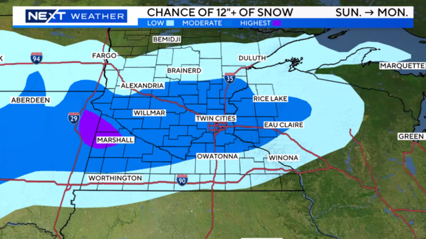
Current models indicate that central Minnesota, including the Twin Cities, could see a foot or more of accumulation between Sunday and Monday.
Tuesday looks to be wet and potentially a little snowy as well. This system will likely clear on Wednesday, and temps will warm on Thursday.
So, how much snow will we get by Tuesday?
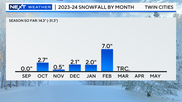
As of Thursday afternoon, the Twin Cities has recorded 14.3 inches of snow this wintry season, with February being the snowiest month so far at 7 inches. Only a trace amount of snow has been recorded in March, but that's about to change.
A clearer forecast of the second storm's snow totals will come into view after the first event is over, but based on what we're seeing already, it could bring in even more snow than the first.
MORE: Xcel Energy urging customers to prep for multi-day March snowstorm
That means some areas could see several inches of snow by Friday and then another several by Tuesday.
If 7 inches or more of snow falls in the Twin Cities by the end of the second system, it would make March the snowiest month of the season in the metro. Anything over 7.2 inches will account for more than half of the season's snowfall total recorded thus far.
The NEXT Weather team is diligently monitoring both storm events, including potential snowfall totals, so check back on WCCO.com for the latest.


