Blizzard warning issued in Minnesota Wednesday. Here's a look at potential snowfall totals.

The next spring snowstorm is heading to Minnesota and is expected to bring blizzard conditions to parts of Minnesota on Wednesday.
Potential impacts from the storm include whiteout conditions and dangerous roads
While the forecast continues to evolve due to how narrow the storm path is, some areas could get close to a foot of snow — especially areas in the southeast.
So, keeping in mind these numbers may change over the coming hours, here's a look at how much snowfall your area could get.
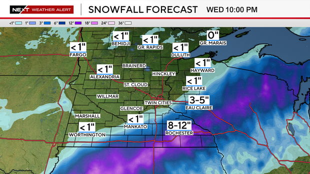
Potential snowfall totals for Minnesota this week
This snow system is expected to impact mostly parts of central and southern Minnesota.
The area that may get the most snow is southeastern Minnesota. Faribault, Albert Lea and Fairmont could all get anywhere from 6 to 12 inches of snow.
After a southward overnight shift in the trajectory, the storm is likely to miss the Twin Cities entirely. Areas to the north and northwest of the Twin Cities are even less likely to see snow.
After the storm clears out, we're in for quiet weather to finish the week. Temperatures will hover in the 40s and 50s.
Another storm system could bring accumulating rain and snow over the weekend, but exact details remain uncertain.


