NEXT Weather: Rain turns to snow early Wednesday; possible flash freeze during morning commute
MINNEAPOLIS – The storm system that rolled into Minnesota on Valentine's Day dropped plenty of rain on the Twin Cities, but it will transition into snow early Wednesday – and make for a white-knuckle morning commute.
The metro set a daily record Tuesday for rainfall, with more than half an inch measured so far at MSP Airport.
The National Weather Service issued a Blizzard Warning for western Minnesota until noon Wednesday due to the combination of snowfall and wind that's reaching speeds of 60 mph. This system isn't dropping a lot of snow, but the wind is causing whiteout conditions, and may roads in the region were closed Tuesday night.
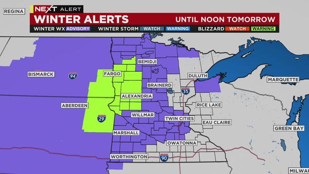
A Winter Weather Advisory has been extended to include the Twin Cities. The rain will turn to snow in the early morning hours, but there won't be much accumulation – likely less than an inch.
The biggest concern for the Wednesday morning commute is the potential for a flash freeze. Expect slick areas and delays.
Wednesday's high in the metro will be 24, and Thursday will be a few degrees cooler. Temps will start to rebound Friday, with 30s returning this weekend.