Rain chances on the way to South Florida after a dry, warm Tuesday
Big changes are ahead in South Florida and today will serve as the transition between the brief stretch of drier weather and the incoming rain.
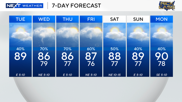
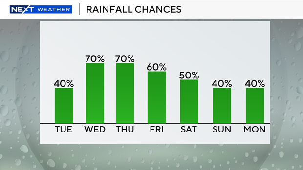
High temperatures will climb to the upper 80s by Tuesday afternoon and scattered storms will develop later.
There is a moderate risk of rip currents along the Atlantic beaches and the UV index is very high. There are no alerts or advisories for boaters over the Atlantic waters and Keys waters.
The drier air above that has suppressed storm activity is in the process of being replaced by deeper moisture returning with a stalled out frontal boundary lifting north. This increase in atmospheric moisture across the region will result in higher coverage of showers and storms during the afternoon hours today as opposed to the sparser coverage from yesterday.
However, in the mid-levels of the atmosphere today, there will still be enough residual mid-level dry air to support the potential of an isolated strong to severe thunderstorm during the afternoon and early evening storms. The main threat will once again be the potential of an isolated strong to marginally severe wind gust from 45-55 mph.
The greatest coverage of showers and storms will be across inland areas as the sea-breeze and outflow boundaries converge during the mid to late afternoon hours.
By tomorrow, not only will the atmosphere usher in deeper moisture, but there will be an upper-level assist from rising air ahead of a dip in the jet stream.
This lifting boost with deeper moisture across the region will kick off the beginning of a stormy period. The Weather Prediction Center has placed South Florida in a level 1 of 4 flood threat Wednesday through Friday.
This means that there is a 5-15% chance of excessive rainfall that may lead to flash flooding.
By the weekend, a notable shift on the latest forecast models now depicts the potential of an area of low pressure developing along the boundary in the western Atlantic.
Lingering moisture will keep the chance of rain high on Friday with storms around, but the chance of rain decreases this weekend.
It will be hotter this weekend with highs around 90 degrees Saturday and Sunday and the potential for spotty storms.