South Florida under extreme heat warning as feels-like temperatures could hit 112 degrees

A heat advisory has been upgraded to an extreme heat warning from 11 a.m. until 7 p.m. this Wednesday due to heat index values of 105 to 112 degrees.
More moisture could also be seen on Wednesday around South Florida, which will lead to even hotter feels-like temperatures due to the humidity.
There is a major to extreme heat-related health risk across South Florida on Wednesday. Heat illness is likely without proper cooling and hydration. Some areas will see little to no relief overnight.

Record heat is possible this Wednesday as highs could reach the upper 90s. It will not be quite as hot Wednesday as it was Tuesday.
Miami hit an all-time record high of 100 degrees Tuesday. The only other time Miami reached 100 degrees was back in 1942. Fort Lauderdale tied its record Tuesday with a high of 98 degrees.

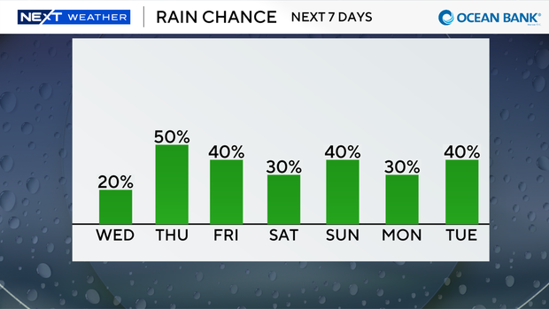
The difference on Wednesday is that some rain will return later to provide a bit of relief as the sea breeze develops. Spotty showers and storms move in this afternoon into the evening. The wet weather will help lower temperatures a little. There is a low risk of rip currents along Atlantic beaches and no advisories or alerts for boaters.
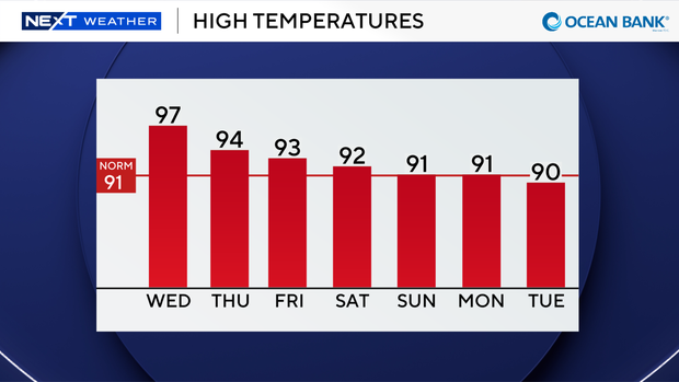
Moisture increases late week into the weekend, raising rain chances. Highs climb to the low 90s Friday, Saturday, and Sunday with the potential for scattered storms every day.
Tropical development is not expected over the next 7 days.