Thunderstorms possible late Monday, early Tuesday, in Metro Detroit


Southeast Michigan residents should be prepared for the possibility of thunderstorms overnight Monday, with a line of storms moving through the Great Lakes region.
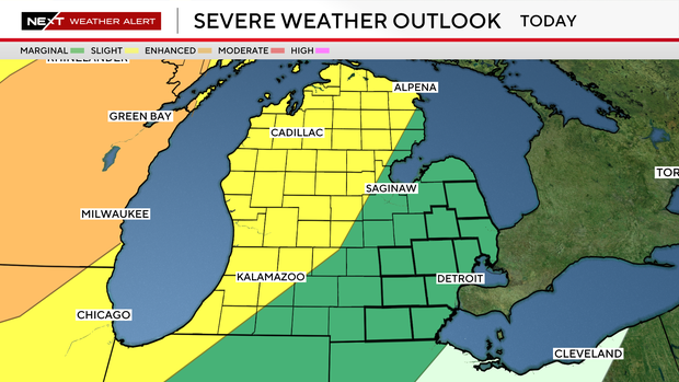
The National Weather Service Storm Prediction Center has placed Metro Detroit under a marginal risk range (1 out of 5) for severe thunderstorms. A higher, slight risk category, includes Grand Rapids and all of the Lake Michigan shoreline area.
The line of storms could produce isolated damaging wind gusts, frequent lightning, brief heavy rainfall and localized power outages in the Detroit area between 2 a.m. and 6 a.m. Tuesday.
Although widespread severe weather is not expected, it is a good idea to stay weather-aware and have a way to receive warnings while sleeping.
Watch vs warning
The National Weather Service says a severe weather watch means "be prepared." It is possible that weather will reach severe levels during the time frame specified.
A severe weather warning means "take action," that severe weather conditions have been reported by spotters or can be detected on radar. People are asked to take shelter indoors, away from windows.
NEXT Weather Alert days
CBS News Detroit declared Monday to be a NEXT Weather Alert Day due to ongoing poor air quality, stepping up forecasts and announcements as needed.
A NEXT Weather Alert Day was declared for Tuesday over the potential for stormy weather.


