Tracking severe storms in Southeast Michigan; NWS issues tornado watches, warnings


Severe weather late Thursday night caused damage in communities and prompted multiple tornado warnings and watches, and thunderstorm watches.
According to Ingham County Emergency Management, officials reported downed trees, one of which damaged a vehicle. Officials also reported that one semi-trailer flipped over, and a tree fell on a house.
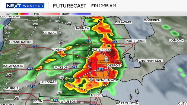
Watches and warnings issued in SE Michigan
A tornado watch was issued in multiple Southeast Michigan counties until 5 a.m. Friday. The warning was canceled. The counties impacted include Oakland, Macomb, Washtenaw, Livingston, Monroe and Lenawee. Other counties under the watch are Genesee, Saginaw, St. Clair, Bay, Lapeer, Midland, Shiawassee, Tuscola, Sanilac and Huron.
A severe thunderstorm warning was issued for Oakland and Livingston counties until 1:15 a.m. Friday. That warning was canceled.
A tornado warning was issued in Livingston County until 12:45 a.m. Friday. That warning was canceled.
A thunderstorm warning was issued in Washtenaw County until 1:30 a.m. on Friday. That warning was canceled.
A tornado warning was issued in northern Oakland County (cities include Holly, Oxford and Lake Orion) until 1:15 a.m. on Friday. That warning was canceled.
A thunderstorm warning was issued in Oakland County (cities include Troy, Farmington Hills and Southfield) until 1:15 a.m. on Friday. That warning was canceled.
A thunderstorm warning was issued in Wayne County until 2 a.m. on Friday. That warning was canceled.
A thunderstorm warning was issued in Macomb County until 1:45 a.m. on Friday. That warning was canceled.
A tornado warning was issued in Oakland County (cities include Troy, Rochester and Birmingham) until 1:15 a.m. on Friday. That warning was canceled.
What to expect, how to plan for severe weather
All the unstable air of the day, our storm fuel, typically begins to subside overnight.
Thursday will be no different, but our gas tank will be much larger than it has been during the past few nighttime events, so the severe weather risk is likely to continue into the night, which is why southeast Michigan has a shot.
The eastern half of the mitten is highlighted as a slight risk (two out of five) for severe storms Thursday night. However, the central and western sides of the state are at an enhanced (three out of five) higher risk, including Lenawee County and parts of Monroe, Washtenaw, and Livingston counties. Our main window is between 11 p.m. and 3 a.m.
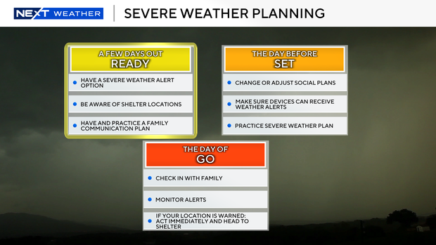
There are quite a few more details to narrow down, and plenty of time to do that, but it's worth looking at your severe weather plans now because this risk is concentrated in the middle of the night.
It's essential to have a way to get alerts while you are asleep, like a phone notification that will override your silent settings, or a weather radio.
The NEXT Weather Team will keep you posted on any changes to the forecast, including timing and specific risks, as we get closer.