Warm temperatures and severe storms possible this weekend

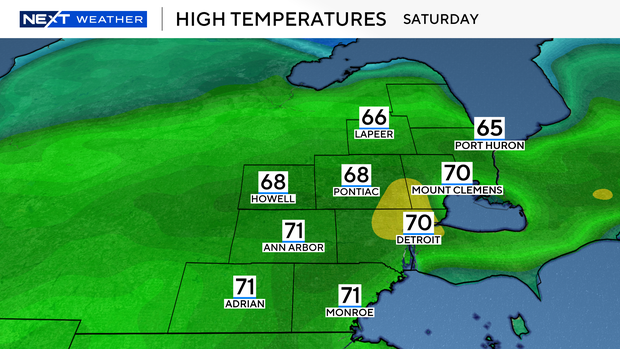
Southeast Michigan is expected to have a second mild day in a row on Saturday, with high temperatures in the 60s to lower 70s.
The day starts out breezy, with wind gusts of 30 to 35 mph forecasted through the first half of Saturday.
Much like Friday, mainly dry conditions early Saturday give way to increasing the potential for showers through the afternoon and evening as the warm front that stalled over northern Michigan slowly releases southward.
A low-pressure system is set to arrive Saturday night, ushering in Gulf moisture. Rain will likely continue through the night, with the potential for heavier showers.
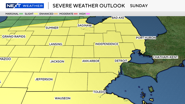
Sunday's temperatures remain on the mild side, with highs in the mid-60s. There will be a Slight Risk (2/5) for severe weather with the potential for all severe hazards during the evening, especially strong winds, large hail, and heavy rain.

Damaging winds would be the main concern for any storms that build in the evening on Sunday as a cold front swings through, but at the moment all severe hazards may be on the table.

Our main window of time looks to be Sunday evening, mainly after 5pm, but that may move around and need to be adjusted depending on how the line forms later in the day.
Stay informed with the latest forecast on any changes and what to expect from the NEXT Weather Team.


