Heat advisory issued for Wednesday afternoon in much of Metro Detroit


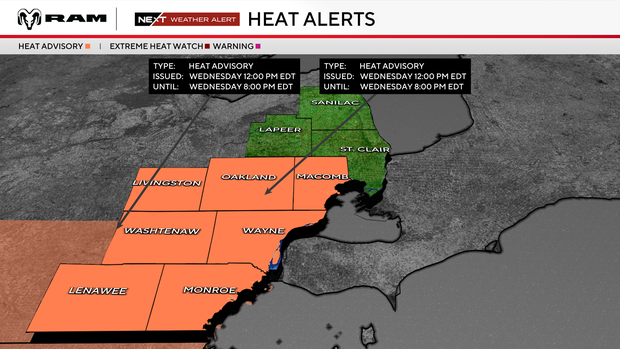
Southeast Michigan is in for another hot and humid day for Wednesday, with afternoon temperatures rising into the lower 90s and heat index values reaching around 100 to 102 degrees in parts of the region.
Given the forecast, the National Weather Service in Detroit has issued a heat advisory from noon to 8 p.m. Wednesday for an area that includes Lenawee, Livingston, Macomb, Monroe, Oakland, Washtenaw and Wayne Counties.
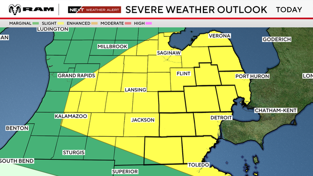
Adding to the weather concerns, the NWS Storm Prediction Center has placed Southeast Michigan in a slight risk zone (ranked 2 out of 5) for severe thunderstorms during Wednesday afternoon and evening. Storms could develop quickly, with damaging winds, large hail, heavy rainfall, localized flooding, and even an isolated tornado possible.
A few storms also were possible early in the day. A severe thunderstorm warning was issued for Genesee County at about 6:15 a.m. Wednesday as a small storm moved over the Flint area.
The CBS News Detroit weather team has declared Wednesday to be a NEXT Weather Alert Day, stepping up forecasts and announcements as needed.
Watch vs warning
The National Weather Service says a severe weather watch means "be prepared." It is possible that the weather will reach severe levels during the time frame specified.
A severe weather warning means "take action," that severe weather conditions have been reported by spotters or can be detected on radar. People are asked to take shelter indoors, away from windows.
Closings and cancellations
Detroit Public Schools Community District will again send students home early on Wednesday because of the hot weather.
Plymouth-Canton schools dismissed P-CEP campus early on Wednesday because of the heat.
The Downtown Monroe City Market, slated for 3 to 7 p.m. Wednesday at Loranger Square in Monroe, has been canceled because of the high heat in the forecast.


