Denver Weather: Sunny And Very Mild Wednesday, Then Snow Arrives Late Thursday
DENVER (CBS4) - Temperatures will soar back into the mid 60s along Colorado's Front Range on Wednesday before a winter storm brings snow almost statewide starting late Thursday. Most areas at lower elevations will be at least 20 degrees above normal for the second week in December. Denver should be at least a degree or two warmer than Tuesday when the city reached 65 degrees. The normal high temperature this time of year is 43 degrees.
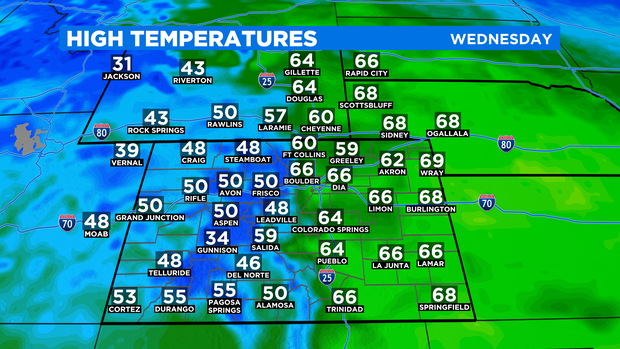
It will be at least 20 degrees colder on Thursday and Friday should be at least 10 degrees colder than Thursday. So get ready to bundle up again!
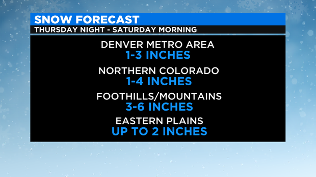
In terms of snow, it will spread from southwest to northeast across much of the state Thursday night. In the Denver metro area, snow showers are possible at any time from Thursday night through early Saturday morning. But even with the snow chances extending more than 24 hours, snowfall amounts are expected to be light.
Most of the Denver metro area should get 1 to 3 inches of snow total including what accumulates Thursday night, Friday, and Friday night. Parts of Northern Colorado could get up to 4 inches mainly in the Fort Collins area west of I-25. The foothills and mountains including Highway 285 above Morrison and Interstate 70 above Genesee should get at least 3 inches.
Skies will clear along the Front Range Saturday afternoon but temperatures remain chilly for the rest of the weekend. Snow chances will continue in the mountains through at least Saturday night.