Colorado's snowpack struggles persist despite weekend snow

Snowpack woes continue across Colorado. Even with parts of the high country receiving over a foot of snow last weekend, we are still lagging significantly behind.
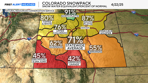
The statewide average sits at 71%. Several factors explain the lack of change from the last winter storm, but the fact that the southern mountains largely missed out is a leading factor.
It is also important to note that this data is based on averages. April tends to be very active, it is the second snowiest on average. This April has not been active. So, this one storm will not be enough to make a dent in the snowpack struggles.
When the National Resources Conservation Service measures snowpack, it divides the state into nine different regions, or river basins.
The two basins struggling the most are the San Miguel & San Juan and Upper Rio Grande basins.
The Upper Rio Grande Basin is currently at 42% of normal, which puts it in the 5th percentile dating back to 1987. This means 95% of the years have had a higher snowpack.
The San Miguel & San Juan Basin sits at 45% of normal, putting it in the 11th percentile.
With the snowpack significantly below average, a wet rest of the month of April and May are crucial.


