Recent rains help improve drought in parts of Colorado

After a few shots of much-needed moisture over the last week, we are noticing several areas of improvement in the drought situation across the state of Colorado.
Every Thursday the U.S. Drought Monitor is issued from the National Drought Mitigation Center in Lincoln, Nebraska. The information released May 26 shows that recent rain from late spring storms have bashed a significant dent in the drought for many areas of our home state.
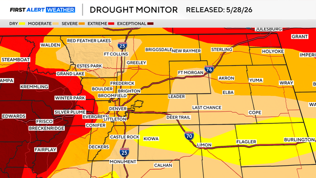
In and around the Front Range, including the Denver metro area, conditions have improved a bit. The drought is still in place but many areas have gone from Extreme down to Severe and Moderate categories. This also, is true for a large chunck of the northeastern plains. Some areas along the southside of the Palmer Divide are now seeing the lowest level of drought in the yellow shades on the map below. Those areas are in the Abnormally Dry category this week. This shows that the rain of the last week has significantly helped the area from Elizabeth and Kiowa out across the I-70 corridor to Burlington and western Kansas.
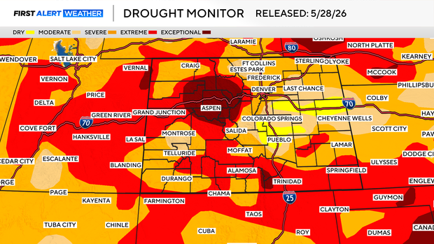
The statewide view shows large improvement for the Pikes Peak region down into the Pueblo area with the Abnormally Dry category expanding into those communities. Even with the moisture help over eastern Colorado, areas of the south and west are still locked into Extreme and Exceptional levels. The worst still being parts of the central and northern mountains near Aspen up to Rabbit Ears Pass and all of Summit county still in Exceptional levels. That's as bad as it gets.
We are still looking at a situation where the only thing that will pull us out of the statewide drought would be several months of above normal precipitation and an above normal or record snowpack next winter.