
Rain on the Way...
For the first time in 10 days, since the October Nor'easter, we will see precipitation...this time around it will be all rain however.
Watch CBS News
For the first time in 10 days, since the October Nor'easter, we will see precipitation...this time around it will be all rain however.
Boston narrowly missed 70 degrees today...we hit 69 before the seabreeze kicked in but many communities did! We'll see another gem tomorrow with highs reaching the mid and upper 60s with lots of sun too.
There are many variables that are factored in for an Indian Summer but in general in November if you have two or more consecutive days of sixty degrees or higher after the first frost then you have one.
A chill was in the air today and the wind certainly didn't help much...highs around 50 felt more like 40 in the gusts.
The high today was 63...sadly that's significantly warmer than many homes due to the power outage...ironically if you opened the windows that would have heated the home in November.
If downed tree limbs, power outages and no heat weren't distracting us, today would have been a top 5 day for the entire Autumn season. I mean, what a gem...all sun, mild temps and no wind...just stunning.
Here we go again, the sky is clearing, the air is very dry and this night is going to be very cold.
A day after our historic nor'easter and many are still trying to pick up the pieces. That, obviously, will take a long time...especially for families in Central and Western MA where most received over 20" of snow!

The main issue this evening (besides traversing through the snow) will be the cold.
Ironically on this date back in 1979 Boston received it's largest snowfall in history during the month of October…1.1″…that will fall along with countless other records in the Northeast and Mid-Atlantic from this early season Nor'easter.

This time around we are talking about an unprecedented October Nor'easter very capable of breaking records for snowfall in the month of October.

A major nor'easter is about to pound southern New England with heavy rain, snow and wind.
I just saw it...my first snowflake of the season...OK I've seen enough! Just kidding...it's kind of a neat scene out there and some of the pics that are on this site here are beautiful.
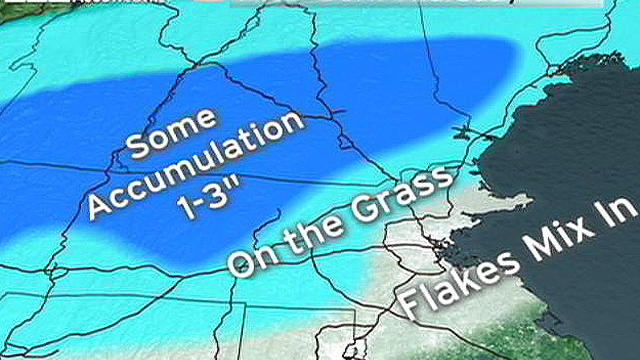
We are forecasting the first snow of the season for many folks in southern New England.
So surprisingly very little has changed with the Thursday / Thursday night storm...usually storms throw a few curveballs at us but this one is behaving very nicely...so far.
Hey folks...so here we go, entering into a much colder and stormier pattern for the remainder of the week. Our first event will be minor and it arrives tomorrow with occasional light rain.
Hey all...a big change in the pattern is coming with a serious temperature drop by the end of the week and a very active storm track that will produce three storms.
An upper level storm to our west will spin due north into Canada we will be on its fringe...close enough for intervals of clouds but not close enough for its widespread shower activity.
A murky start turned into a gem of an afternoon...balmy and breezy too!
Almost all towns have eclipsed the one inch mark and parts of the South Shore and Cape are closing in on two inches of rain from today's system.
So far this year, only three months (July, May and March) have had below normal precip...and most of the wet months haven't just been slightly above normal but inches above normal...we had enough already!

It's time to start preparing your garden for winter.
The fine weekend weather has spilled over into the start of the workweek...temps have once again exceeded average high levels and ample sun has been seen. Tomorrow will be another tranquil day as we wait for a powerful rainstorm to come charging up the coast for Wednesday.
A potent system will be passing through over the next 24 hours once again delivering some soaking showers and maybe even some thunderstorms.
The longest stretch of dry weather since the middle of July...8 days... is about to conclude.