A Hot One...
Last month we had six 90+ degree days, so far this month we've only had one. That could change tomorrow as heat builds in for one day before a front moves through and cools us off for the weekend.
Watch CBS News
Last month we had six 90+ degree days, so far this month we've only had one. That could change tomorrow as heat builds in for one day before a front moves through and cools us off for the weekend.

As promised the muggy air would return and dewpoints have gone from the upper 50s yesterday to the upper 60s this afternoon. This along with an advancing frontal system has lead to tropical downpours and will lead to more.
A solid summer day out there with a good deal of sun and even though temps climbed above normal, into the mid 80s, it wasn't oppressive due to the low humidity.
I don't know about you but for me, this past weekend was gross...the air was so oppressive that the rain from thunderstorms didn't even make it better...in fact, it made it worse!
A coldfront passed through the region today and will settle to the south in our coastal waters for the weekend.
As expected, the dangerous thunderstorms that formed today did so to our SW where Connecticut, New York and Pennsylvania saw a nasty line of storms that marched hundreds of miles knocking down all kinds of trees and structure in it's path.

The Storms Prediction Center has put much of southwestern New England in a moderate risk category for severe weather. Unfortunately, an isolated tornado cannot be ruled out later today.
That must have been a top ten day...gosh, I didn't want it to end!

Todd traveled to Nightingale Community Garden in Dorchester, just one of dozens of green spaces located within Boston's city limits.
Nice weather from the weekend spilled over into today but unfortunately it won't have the legs to make it through the entire week.
Well that was a fun day, I hope you had a least a few memorable moments outside in the lovely mid-summer air today.
"What a weekend", that's what we will all be saying come Monday.
The heat is gone, the humidity is lowering and the severe storms are out of here...life is good again.
Hey folks, sorry for the late post...today was obviously a bit crazy. We had several reports of severe weather today including a funnel cloud over the North Shore and a microburst in Arlington. So how do the two differ?

Severe thunderstorms ripped through Massachusetts Wednesday afternoon, bringing strong winds, hail and frequent lightning.
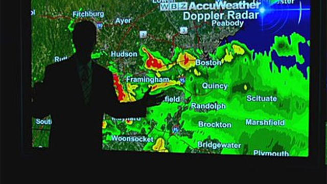
WBZ-TV Chief Meteorologist Todd Gutner was forced to finish his forecast in the dark after a lightning strike knocked out power.
Some impressive heat today invaded New England on this day 6, for some, of the heatwave.
At noon today, the wind was blowing out of the North at 13 mph with gusts to 22mph at Logan...the temperature was up to 88 degrees and we were on our way to four days in a row of 90 degrees or higher.
Many towns climbed to 90 or above today including Boston, Groton, Revere and Arlington...for most towns in the Merrimack Valley this was day two of an extended heatwave. High clouds and southerly winds precluded temps from getting to 90 degrees for most towns south of the Mass Pike.

We are at the very start of what promises to be one of the longest stretches of hot and humid weather of the summer.
These won't be the hottest temps we've experienced this season but this will likely be the longest hot stretch
Not much to add tonight, as Mother Nature continues to pound the strike zone with fastballs so the forecast remains unchanged.
Another gem here in Southern New England...highs maxed out in the upper 70s at the coast and mid 80s inland.

Here are some helpful tips to help you keep your yard looking its best even in the middle of the summer.
This past Winter wasn't bad at all but when Winter gets rough, I think about weeks like this one...sunny, warm and low humidity. In my mind it really doesn't get much better than this.