Hurricane Sandy's Peak In Southern New England Comes This Afternoon
The peak of Sandy for southern New England will come between noon and 8 p.m. Monday.
Watch CBS News
The peak of Sandy for southern New England will come between noon and 8 p.m. Monday.
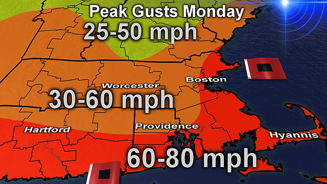
Hurricane Sandy is bearing down on the East Coast with maximum sustained winds at 85 mph Monday morning.

We've been talking about Sandy for a week now, and it's arrival is Monday.

Boston Public Schools will be closed Monday and all non-essential city employees have been advised to stay home.
The National Hurricane Center says this could be the largest tropical storm ever in the Atlantic Ocean.

As Sandy continues her path up the coast, Massachusetts Emergency Management is preparing state residents for power outages.

President Barack Obama has spent months trying to balance his re-election bid with running the government.

Massachusetts officials have opened the state emergency operations center in Framingham to get ready for Hurricane Sandy.

Confidence continues to increase for the track and severity of Sandy this morning. Nearly all weather models forecast a landfall in Central New Jersey Monday night.

A list of storm-related closings.
A calm Saturday did not reflect what Sandy has in store for the coming days.

This is going to be a powerful and damaging event but likely not be a catastrophic event.
It looks like Sandy is going to hit New England no matter what its track is at this point.

Historically, this storm will rival many of the past storms that have impacted New England. Not only will the track be unique, but also the intensity will be one for the record books...with minimum pressures falling to levels comparable to some of our greatest hurricanes! Just Incredible.
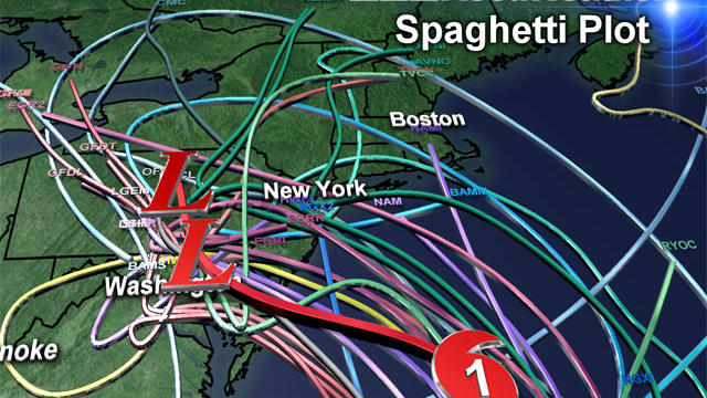
If we take a direct hit Sandy would go down in New England weather history joining some of the more memorable storms like the Blizzard of '78 and the Perfect Storm.

Our midday and afternoon models are pouring in and forecasting some significant changes in the ultimate track of Hurricane Sandy.
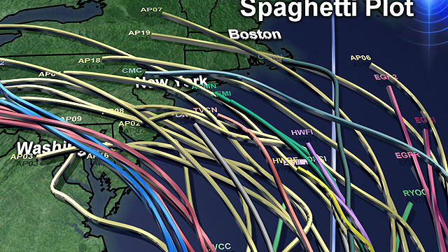
Some major developments in the past 24 hours with regards to Hurricane Sandy and its eventual track up the Coast…First of all, Sandy strengthened overnight into a category 2 hurricane.

The likelihood of New England feeling some effects from Sandy is increasing.

Despite a cold frontal passage today, the immediate post-frontal air mass will be summer-like with high temperatures reaching the lwr-middle 70's in many locations, with the exception of the Cape and Islands where winds off the water will keep temperatures closer to 70. Average highs this time of year are around 60 degrees, so we'll be 15 degrees above normal to start the weekend! Southwest winds will be breezy at 10-20mph.
Steady Showers are being directed up the CT river valley for the morning hours with lighter showers across eastern MA. By afternoon, the steady showers in the west will begin to shift eastward for the afternoon and evening.
High pressure is parked off the coast today providing abundant sunshine, sparkling blue skies and a very pleasant fall feel. Light winds from the SE will keep it slightly cooler at the coast this afternoon as most areas will climb to 60-65. A beautiful seasonal airmass for this time of year.
Believe it or not Earthquakes happen on a frequent basis in the Northeast. In just the past month, we have had 7 small tremors. The Northeast averages about 40-50 earthquakes annually...most of them are small and do little if any damage.
Today, the feel of fall returns with a wind shift back to the NW. Early morning showers along with the front have pushed of the coast with rapidly clearing skies following in for the morning hours into the afternoon as skies.Skies will become mostly sunny with a chilly breeze from Canada which will help to keep temps about 15-20 degrees cooler than yesterday...so don't forget the warmer clothes.
Clouds are increasing ahead of a cold front with skies becoming mostly cloudy. Breezy balmy SW winds in place for Monday will bring temps from the 60's this morning to near 70-75 by this afternoon with gusts to 20-30 mph.
A widespread killing freeze is likely overnight with many areas spending a few hours in the 20's around dawn Saturday. After a frosty cold and clear start, Saturday will be filled with sunshine with highs around 50-55. Temps running below normal, but light winds in the sunshine will make for a very nice afternoon.