Another Chance for Storms Tuesday
Watch CBS News

A warm and muggy night, but a cold front will push off the coast and drier air will move in overnight with clearing skies and lows in the 60's. Tuesday will be a warm, but less humid day. There will be plenty of sun in the morning, but cooler air aloft supplied by an upper level low over us will keep the air unstable. Expecting building PM clouds with the potential for a spot shower or thunderstorm. Breezy WNW will warm the coastal plain with many areas climbing into the mid-upper 80's
Monday will be a hot and more humid day with hazy sunshine and scattered afternoon storms. Most areas will reach near 90 degrees.
Isolated to Scattered Strong to Severe Thunderstorms are likely Monday Afternoon and Evening across the entire NWS Taunton County Warning Area. Damaging Winds, Large Hail, and urban/poor drainage flooding are the primary threats..
Our weather outlook here at home is fairly tranquil, but there is a little weather to watch once this awesome weekend is in the books. Today many areas approached 90...but most did not reach it. Sunday will be a tad cooler with Sunshine and highs in the mid 80's. Lighter NW winds will shift onshore for a PM sea breeze which will cool many area beaches into the 70's during the afternoon.
After a muggy start, dewpoints have been dropping in the 50's and Lwr 60's along a breezy and refreshing NW wind which has been gusting to 25 mph today. An epic day for sailing on the water. A rising barometer behind a cold front has allowed crystal clear skies across the region with barely a cloud in sight. Highs will be climbing into the upper 80's to near 90
Abundant cloud cover remains over southern New England. Periodic light showers have crossed this morning with a shortwave riding ahead of the front. High pressure over Canada will edge closer towards the region with increasing sunshine and drier air for the Northern new England. Across the south is a bit of a different story. Mostly cloudy conditions will be in place for most of the day with periodic light showers south. Highs will be warm in the Lwr-mid 80's.
One more day of intense heat is likely, but clouds so far have slowed the temp rise. Clouds are quickly starting to erode and give way to increasing midday-afternoon sunshine. The sun with west winds should be enough to spike the temps back up into the mid -upper 90's...where clouds hold on longer, temps may struggle to get into the the Lwr 90's. Heat advisory remains in place through 6 PM tonight.

There is a chance that Boston could equal or eclipse the all-time record for hottest temperature ever recorded in the city, set way back in 1911.

With high pressure overhead, drier air, light winds and clear skies...we are in store for a gorgeous summer night with temps dropping down to 60-65 in Eastern MA...with lows in the 50's in western valleys. More sunshine for Wednesday with temps once again climbing towards 90 with moderate humidity.
Best chance of any thunderstorm activity now will be from 6pm-12 am, and any storms that form could contain very heavy downpours, frequent lightning, damaging winds and some small hail. The atmosphere is very ripe in extreme Southern New England (parts of CT, RI and SE Mass and farther south towards the Mid Atlantic). So those would be the most likely areas for any severe weather later this evening.
High pressure is firmly in place across New England today providing abundant sunshine. Light NW winds will shift to the WSW as the high slides off the coast. Today will become very warm with highs climbing into the upper 80's to near 90 in many locations. Cooler on the Cape & islands around 80-85

Boston's aging pipes are leaking explosive methane gas and it may be occurring in a neighborhood near you.
Just an awesome summer day out there with sunshine, warm temps in the 80's and moderate humidity. It all is making for a perfect weather combo. High pressure pulls off the coast later today and warmer more humid air will begin to wrap in Monday.
This first batch of rain/thunderstorms will finally be winding by late morning/midday. Still the atmosphere will be ripe for more scattered cells and storms to pop up in the afternoon. There should be a little bit of a lull once this first round pushes off the coast for the afternoon. Highs in the Lwr-mid 70's
The cold front which helped to trigger strong to severe storms late yesterday across the Pioneer Valley has weakened and stalled over southeast MA. This cold front will likely become the trigger for a few scattered showers or thunderstorms to form later this afternoon across Bristol, Plymouth and Barnstable counties. These areas, including along the south coast have dewpoints in the upper 60's to near 70 which will help to fuel the scattered afternoon convection.
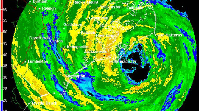
Last year was third most active hurricane season on record, with 19 named storms, but none made landfall. Experts feel this year could be much different.
A look at average high temperatures show the peak occurs in July, though August temperatures typically are also warmer than June-the month of the summer Solstice.

A 30-foot bus-sized space rock named 2011 MD, missed the Earth by a mere 7,500 miles on Monday.
Morning Low clouds are thinning and breaking for some increasing midday and afternoon sunshine. Low clouds linger a bit longer at the coast...especially on the Cape. West winds along with increasing hazy sun will give a warm muggy to feel to the air this afternoon with highs climbing into the 70's and Lwr 80's. Light winds will mean a seabreeze at the coast
We are left with abundant low clouds which are pretty much stuck over us for the rest of the day. The low clouds will try to lift by the midday into the early afternoon for perhaps some brightening and thinning to the overcast for a few breaks of sun. That is about all...but the good news is most of the day will be on the drier side so any outdoor plans should be fine despite the clouds, cool onshore winds keeping temps in the 60's to near 70.

The weather pattern that made for a wild winter across the Northeast, active killer tornadoes and flooding this spring and cooler than normal weather is finally coming to an end.
A sunny and pleasant day today as dewpoints continue to drop making it feel very comfortable outside. Upper low over the maritimes wrapping in dry Canadian with building high pressure at the surface providing mainly dry pleasant conditions for the next 48 hours
Highs will climb into the Lwr 80's with a warm humid feel. We are tracking a shortwave which will be pushing south into New England. A cold front will push through the region during the afternoon and likely fire up some scattered convection in the form of a few showers or thunderstorms. The best chance of these showers and storms will be around 2 PM-6 PM before exiting the coast tonight.