What is the polar vortex? Why it could open the door for significant winter weather in Massachusetts.

Every year, the winter buzzwords start to fly before we set the Thanksgiving table. And who doesn't love feasting on the polar vortex?
Everyone's favorite (or favorite to hate) phenomenon spins up in fall and its strength throughout the season tends to have an influence on whether we shiver or saunter our way through winter. This year, it's getting knocked around early.
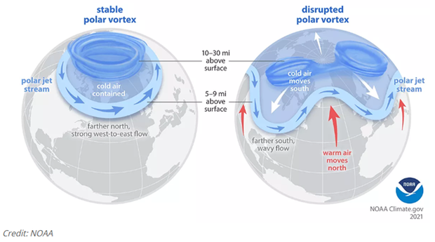
So, quick vortex refresher. There are actually two of them. Down low, in the layer where our weather happens - the troposphere - we've got what most people simply call the jet stream. That fast river of air steering storms and deciding whether we get a nor'easter or a nice day. The jet stream marks the boundary of the tropospheric polar vortex, with the real deal frigid stuff on the north side of it (in our hemisphere) and milder air to the south of it.
But there's a second one, a companion vortex way higher up - about 10 to 30 miles above us in the stratosphere. It revs up in the fall, slows down in the spring, and usually blows west to east just like its counterpart down below.
Now here's where things get wild. The atmosphere behaves a lot like water, so think waves - big, slow, planet-sized waves. During a sudden stratospheric warming event, one of these waves pushes north toward the pole and breaks in the stratosphere. As it crashes down, air sinks and rapidly warms - sometimes by 100 degrees in just a few days. That can shove the polar vortex off the pole or even split it apart.
When the warming is strong enough, it totally rearranges the temperature balance up there. The winds don't just weaken - they reverse direction. Instead of blowing west to east, they turn around and blow east to west. And when the vortex weakens like that, it has a habit of letting Arctic air spill southward into the places where most of us actually live. The effects can linger for a month or more.
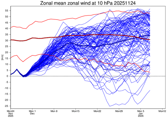
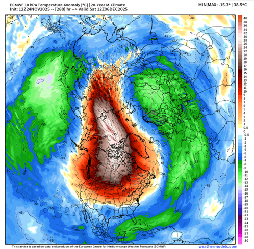
Will winds reverse direction?
That is what's on the fringe of occurring this week (the very end of November). We've been watching to see if the winds will reverse direction, and it's a nail-biter. During the final weekend of the month, it will either barely meet the criteria (passing that 0 line on the figure above) or just barely hold.
Regardless, the impacts may not be very different either way. The overall atmospheric pattern favors a weak vortex this winter, which should allow for several of these close calls which we often refer to as "stretched vortex events." During each of these, cold air can descend down into the mid-latitudes where we live.
The last time we saw one this early was way back in November 1968 - and New England went on to have a very cold, snowy winter. There was record-breaking snow in the northern New England mountains, and more seasonable levels of snow (though with plenty of cold) in southern New England.
But - and this part's important - a SSW doesn't guarantee a blockbuster winter every time. There's usually a lag of at least a couple of weeks before anything reaches the surface. Still, the odds go up. So, as we look toward mid-December into January, the door is opening for some potentially significant winter weather. And compared to some of our quiet winters of late, it could mark quite a departure for us!