Tropical Storm Elsa Brings Heavy Rain, Gusty Winds And Potential Power Outages
BOSTON (CBS) -- The entire east and southeast portion of Massachusetts are under tropical storm warnings for Tropical Storm Elsa.
A Flash Flood Warning has been issued for the Boston area, as well as Middlesex, Worcester, Norfolk and Bristol counties until 4 p.m. Friday.
WATCH: CBSN Boston Live Coverage Of Tropical Storm Elsa
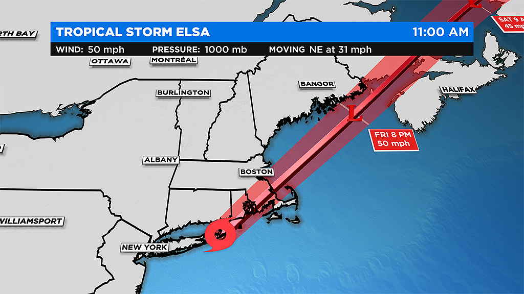
While Elsa will be a quick mover to mid-afternoon, there are several reasons for concern in our area.

TRACK: Tropical Storm Elsa
Here's what to expect:
RAINFALL:
The heaviest rain will fall to the west of the track which includes most areas west of I-95. There could be as much as 5-to-6 inches of rainfall in parts of our area through midday Friday.
WINDS:
The strongest winds will be to the east of Elsa's track which is likely to include the immediate coastline of the South Shore and certainly Cape Cod and the Islands.
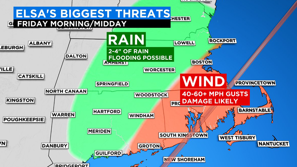
In this zone, there is a threat for tree and power line damage and numerous power outages. Wind gusts 35-to-55 mph are likely to the east of I-95 in Mass. Farther southeast over extreme southeastern Mass. and the Cape/Islands, winds could gust 55-to-70 mph out of the south-southeast.
COASTAL WATERS:
While we don't expect much storm surge or coastal flooding with Elsa's passage, the seas will be very angry with swells 10-to-20 feet just offshore, particularly on our south facing beaches along the South Coast. Dangerous rip currents and marine conditions will exist for most of the day Friday.
TIMELINE:
The heavy rain circulation directly associated with Elsa will continue through the afternoon. Torrential downpours will continue off and on producing 2-to-4 inches of rain, locally higher amounts of 5-to-6 inches.
This rain will fall in a short period of time leading to street and flash flooding with some roads becoming flooded and nearly impassable. It is never safe to drive through a flooded road.
The strongest winds (in extreme eastern Mass., Cape, Islands) will occur between 7 a.m. and 4 p.m. on Friday as Elsa's center rides up and over our area. Again, south-southeast gusts as high as 55 mph are likely across this entire area with the potential for a few up to 70 mph on the Outer Cape and Islands.
With tropical systems passing near or overhead, there is always an enhanced risk of severe weather, perhaps even an isolated tornado. This is something else we will be closely watching through this afternoon.
The rainfall will quickly shut off during the afternoon from south to north and nearly the entire rain structure will be up in Maine after 1-to-2 p.m. and quickly racing northward toward Canada. The winds will remain gusty along the coast for a few additional hours, through about 4-to-5 p.m. before easing.
We will get rapid clearing Friday evening and other than a few stray showers, we have a fairly nice weekend ahead with temperatures near or slightly above 80 degrees. Just what the doctor ordered after a very busy, wet week of weather.
Follow Terry on Twitter @TerryWBZ


