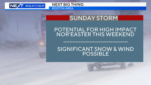
Snow storm this weekend? First nor'easter of year in Boston area possible Saturday into Sunday
How much snow are we getting in Boston this weekend? The WBZ NEXT Weather team is getting ready for a potential nor'easter in Massachusetts.
BOSTON - After a December to remember (or forget depending upon your preferred weather) in which Boston finished in the top 5 all-time for warmest and least snowy, it sure looks like the winds of change are starting to blow.
Snow is finally in the weather forecast
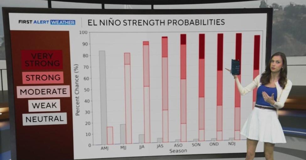
By now, you have likely heard that this is an "El Nino" winter. There is a strong El Nino going on right now and that is going to continue to have a major impact on our weather going forward. The typical El Nino wintertime playbook is for a slow start to winter and a mild December. Check.
January and February tend to be a bit colder, snowier and also bring the potential for some big east coast storms. And, wouldn't you know it, that is exactly what most models are predicting in the coming weeks.
The pattern ahead has a classic mid-late winter El Nino look. This includes a very active southern storm track with several storms crashing into the western United States and then diving southward towards the Gulf of Mexico. The big question for us here in the Northeast is - what happens from there? They won't all be "hits" for New England, depending on the storm track and changing atmospheric setup, there will likely be some storms that miss completely to our south (see this Thursday).
But, I think it is safe to say, they won't all be misses either. A handful of these storms are likely to take the turn northward and barrel up the East Coast bringing a variety of impactful conditions and precipitation types from the Mid-Atlantic to New England.
That brings us to this weekend and our first chance at a legit nor'easter and plowable snowstorm this season.
When is it going to snow?
As of this writing, there is a storm system about to come ashore on the west coast. This storm will traverse the country this week, diving southeastward through the Rockies, passing through Texas on Friday.
Late Friday night, the storm will receive an infusion of energy and moisture from the Gulf of Mexico.
On Saturday, the storm will be gaining strength and rapidly deepening over the southeastern states. It will bring periods of heavy rain from the Carolinas down through Florida and several inches of snow to parts of the Appalachians.
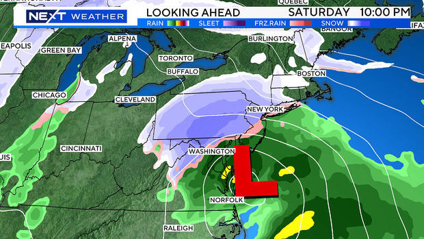
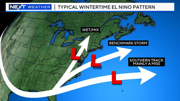
From here, the track is key. Most models are now favoring a center track just south of New England, somewhere fairly close to the 40N/70W "benchmark" just south of Nantucket.
If this were the case, look out. We call it the benchmark for a reason, this is the area through which most of our bigger winter storms pass through (or near) giving southern New England its highest odds for an impactful snow and wind event.
There is a lot of potential here and it would be wise to start doing some simple things to ensure you are ready. Gas up the snow blower, put out your driveway stakes, and, if you have travel plans on Sunday, perhaps consider a backup plan just in case.
How much snow this weekend?
What could we be talking about given a worst case scenario?
- Plowable snowfall for a large portion of southern New England.
- Strong, potentially damaging east-northeast winds.
- Some minor coastal flooding. Thankfully the tides are astronomically low this weekend, so we can likely rule out major coastal flooding.
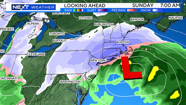
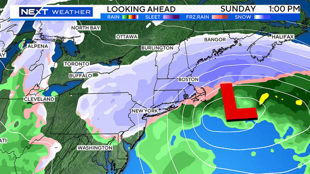
- While the brunt of the storm appears to be Saturday night and Sunday, there would likely be major disruption to travel for much of the Northeast that would linger into Monday.
There doesn't appear to be a ton of mixing with this storm. Most of the area will see only snow. The best chance of rain or a mix would be on the outer Cape and Islands.
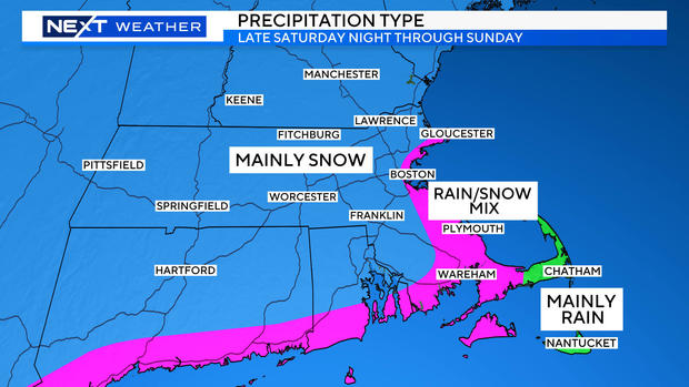
Also, given the strong onshore winds (and ocean temperatures in the mid 40s), right along the immediate coastline (from Cape Ann to Boston to the South Shore) there may be some brief mixing. At the very least, the snow will be much wetter and heavier in nature in those areas.
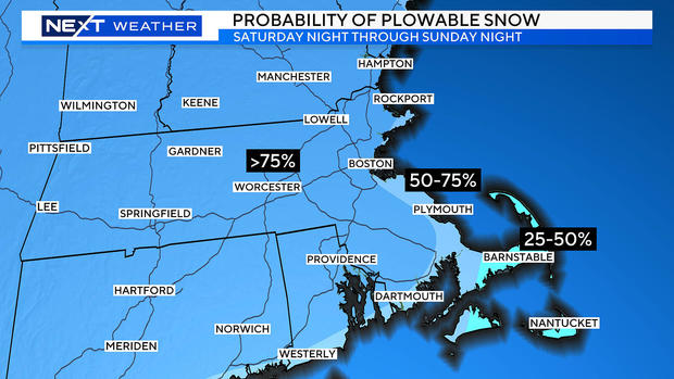
There is a fairly high probability (greater than 75%) of plowable snow for most of southern New England. Again, those chances begin to lessen in far southeastern areas including the Cape.
And, this could be just the beginning. There is another strong storm signal around the middle of next week. Early indications are for a track farther west than the weekend storm, which could lead to a mess of rain, ice and snow. It is certainly possible that when all is said and done, we may look back at the next several weeks as being the most active and impactful of the entire winter.
Obviously our WBZ-TV NEXT Weather Team will keep you posted every step of the way with continuous updates on WBZ-TV, WBZ.com and streaming on CBS News Boston. You can expect more details and specifics as we get closer to the weekend and we will alert you to any forecast changes immediately! Stay tuned!