How much will it snow in Boston this year? Here's a 2023 winter forecast from the WBZ Weather Team
Will winter 2023 mean a lot of snow in Boston? The WBZ NEXT Weather team shares their predictions for Massachusetts, and the role El Nino plays.
BOSTON - Let's start with the obvious - this winter can't get any more lame than last year. Winter 2022-23 was about as boring and low-key as it gets here in Massachusetts.
Boston didn't get its first inch of snow until the middle of January. I did not have to shovel once all season and mustered only one muddy day with the kids trying to sled through a couple inches of slush. It was the fourth warmest winter on record at Blue Hill Observatory, with a particularly mild January at its center.
That's a long way of saying that this year will have more action than last! If anything, I think we can at least bank on that. But exactly how much more might we expect the weather gods to dish out?
What is an El Nino winter?
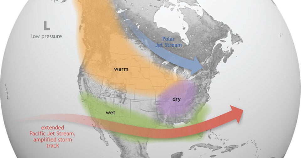
Each season we often start out with one of the biggest variables that guides global climate - the El Nino Southern Oscillation (ENSO). After three straight years of La Nina being in charge, we rapidly saw the equatorial Pacific shift gears to a strong El Nino event. That means a stripe of cooler than average waters extending off South America transitioned to much warmer than average water.
Often, this is a death blow to winter around here. There have been eight strong to very strong El Nino events since 1950, and every single one of them had at or below average snowfall. In general, strong ENSO phases offer the least snow here (both El Nino and La Nina) with many of our biggest winters coming when the ENSO signal is weak.
In addition, there's another region of the global oceans we watch. The Indian Ocean has a dipole that can be in a warm or cool phase, just like ENSO. We call it the IOD. This autumn, we find that the IOD is in a very positive state, which coupled with a strong El Nino is an even stronger signal for a mild winter. Think 2019, when a nearly identical strong +IOD helped produce a strong polar vortex that dominated all winter.
BUT this year there are a couple of caveats.
While considered a strong El Nino event by the typical oceanic measure, this one doesn't seem to be speaking to the atmosphere as strongly as most other events. In other words, the ocean isn't quite as connected to the air above it as we would expect. Perhaps this is related to yet another variable we track, the Pacific Decadal Oscillation (PDO). It has been strongly negative, which is not typical during a strong El Nino. Usually, it turns positive and the Lower 48 gets blasted with mild Pacific air for much of the winter. There's reason to believe that effect may be muted this time around. I would also point out that disruptions to the polar vortex are more likely during El Nino than La Nina, so 2019 may not be a good comp for this year.
Regardless, we can at least go through the historical record and take a peek at what generally happens when you have a strong El Nino and a +IOD heading into winter. The result is that your mildest month is December in this part of the country, and that signal fades as the season goes on. Likewise, snowfall chances go up as the mild pattern loses its hold.
Big thanks to @webberweather and @WorldClimateSvc on Twitter for some of their analysis in this regard!
When will it snow in Boston this year?
But what does it all mean for us?
Last year, we expected December to be the coldest month versus average of the season, and it was. This year, we expect the opposite. It should feature the mildest air and lowest chances for sustained snowfall. This would be the case with El Nino plus the +IOD on their own, but especially true since it appears the polar vortex will be in a strong state during most of the month.
I feel this will be another one of those winters where the season doesn't really get going until around MLK Day weekend - January 13, 14 and 15, 2024. That's when mild influences should back off, cold shots could become more common, and we'll be on the hunt for bigger snowstorm potential.
And that's another hallmark of El Nino - a strong subtropical Jetstream that can juice up storms across the southern states to the mid-Atlantic. There's usually big storm potential in that MLK Day to Valentine's Day window. I feel that's where we may have our heart of winter this year. The question is always whether the track supports flatter tracking or up the coast tracking. 2009-10 is a season that clobbered the mid-Atlantic with snow but only brushed our area. It may come down to getting the one or two big storms that determines whether we have a close-to-average season for snowfall or one that remains below.
I'm aiming for something that starts out slow but makes a charge in that second half that gets us close to average, but a bit short.
As for temperatures, the smart money always starts with warmer than average and then looks for reasons why maybe that won't happen. The last time Boston had a colder than average winter was almost a decade ago, in the BIG winter of 2014-15. As the climate warms, it almost always pays to hedge milder.
Also consider that of the eight strong to very strong El Nino events in the past 75 years, every single one of them was warmer than average. So while cold shots will still come, it is likely that the winter as a whole will average out to be warmer than average again, with December carrying the greatest weight in that average.
Bottom line? A milder than average winter with slightly below average snowfall in Boston.
What about the surrounding Boston area?
I'll leave you with this nugget. If you look across the country over the past 50 years, you will see that almost every area has seen a trend of decreasing snowfall. Of course, that makes sense as winters warm. However, right here in the I-95 corridor from Maine to Massachusetts to New York City we are bucking the trend. We've had a slight *increase* in snowfall!
Why? I think the shape of that anomaly makes a lot of sense. It's the perfect shape of a nor'easter crawling up the coast. We've seen bigger storms in recent years, producing more snow when they do hit. It's been the golden age of big snowstorms. It may not last on the ground as long, but when it snows it has been snowing buckets. This may be a similar year where the vast majority of our snowfall comes in 1 or 2 big storms.
We'll check back in during March for the post-mortem!


