Massachusetts on "razor's edge" with weekend storm. Maps show best chance for snow, high winds.
Boston is dodging a major bullet in the weather forecast this weekend. We are avoiding a worst-case scenario as a storm will not track close enough to New England to deliver what could have been a devastating and destructive blow.
We now are focusing most of our attention on southeastern-most Massachusetts for greatest impacts.
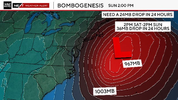
What is a bomb cyclone?
You may have heard some scuttlebutt in the media about a "bomb cyclone."
That is just a cool, fancy way of saying that this storm is going to undergo a rapid deepening, known as bombogenesis. It will transform from a semi-regular area of low pressure early on Saturday to an absolute beast of a storm by Sunday morning.
We are riding the razor's edge with this storm. Oh so close to another big snowstorm.
Cape Cod juts out to the east just far enough to catch the western fringe of the massive snow shield.
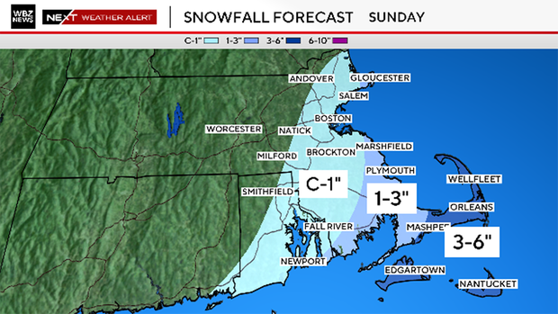
How much snow will Massachusetts get?
Here is our snowfall forecast map. The best chance for a plowable snow is clearly over Cape Cod and the Islands.
Those chances drop precipitously as you travel north and west of the canal.
We are forecasting:
- 3-6" from the mid to outer Cape and for Martha's Vineyard and Nantucket
- 1-3" near the Cape Cod Canal north to Plymouth and also the South Coast
- Coating to 1" along the rest of the Massachusetts coastline including Boston and the North Shore
The National Weather Service has issued a Winter Storm Watch for the Cape and Islands given this snow threat.
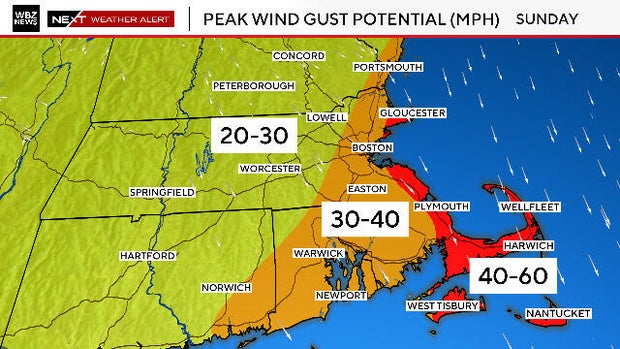
High wind gusts
The winds will be howling along the South Shore, Cape Cod, Cape Ann, and the Islands on Sunday. Not a nor'easter this time, the wind direction will be north and then northwest.
We expect gusts to reach 40-to-60 mph in this area.
Just inland, back through I-95, wind will gust between 30-to-40 mph.
For the remainder of the area, 20-to-30 mph gusts, certainly noteworthy.
The peak gusts will occur Sunday midday through early Monday morning.
Coastal Flood Watch
The wave heights over the open Atlantic look more like something you would see during a hurricane passage.
There will be large waves and swells along the entire stretch from New England to the Carolinas.
We may see waves as high as 6-12 feet at east and northeast-facing beaches on Sunday and Monday.
Given that we are facing high astronomical tides this weekend, there is extra, added concern for coastal flooding, particularly at north or north-northeast facing beaches.
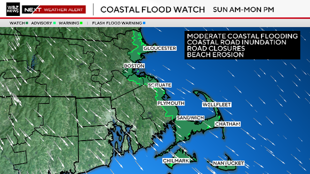
It won't take much of a storm surge to cause moderate levels of coastal flooding.
There will be 1-2 feet of water inundating many of the typically vulnerable coastal roads, some of which are likely to be closed Sunday and Monday.
Since our tides are astronomically high this weekend, we do anticipate the storm leading to some minor to moderate coastal flooding along north or north-northeast facing beaches.
The dark red bar is the actual predicted high tide. The lighter red is the forecast with a storm surge included.
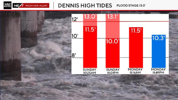
You can see that areas like Dennis are predicted to see waters over flood stage Sunday late morning and again Sunday before midnight.
Our WBZ NEXT Weather Team has you covered. We will provide frequent updates all week on WBZ-TV and WBZ.com. When we know, you know.