Hurricane Isaias to have some impact on Boston weather forecast for holiday weekend
Hurricane Isaias is officially the first hurricane of the Atlantic tropical season, and while the greatest risk from this storm is for those in the Gulf Coast states, particularly between New Orleans and Panama City, Florida, we do believe some impacts will be felt in the Boston weather forecast.
Isaias is currently located less than 400 miles south of the mouth of the Mississippi River.
Hurricane warnings are in effect from Ocean Springs, Mississippi, eastward to the Bay/Gulf county line in Florida. There are tropical storm warnings westward to parts of Louisiana and farther eastward into Florida.
Hurricane Isaias path
The current National Hurricane Center forecast track takes the center of Isaias just east of Mobile, Alabama.
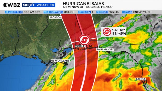
This track is critical for folks living in that area as any little wobble east or west will have huge consequences.
Ultimately, the worst conditions will be just to the east of the center of the storm.
The peak rain and wind will occur Friday night through early Saturday along the Gulf Coast.
We expect winds to gust between 60-90 mph close to the center of Isaias.
Several inches of rain are likely from the coastline through a few hundred miles northward, including Atlanta.
As is the case with all tropical systems, Isaias will rapidly deteriorate as it heads inland.
It will likely be downgraded to a tropical storm on Saturday and just a remnant low pressure area later in the weekend.
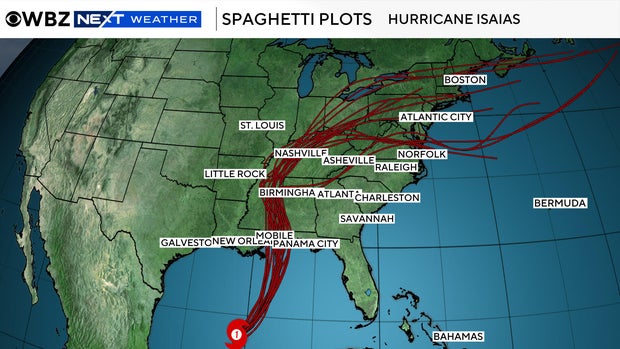
The remnants are forecast to bring rain up through St. Louis and Nashville and then take a right hand turn later on Sunday.
Boston weekend weather forecast
So, what does this mean for us here in New England?
During the day on Sunday, the outer shield of high clouds will enter our area.
At first, just some high cirrus clouds, but these will thicken as the day goes on Sunday, meaning decreasing sunshine.
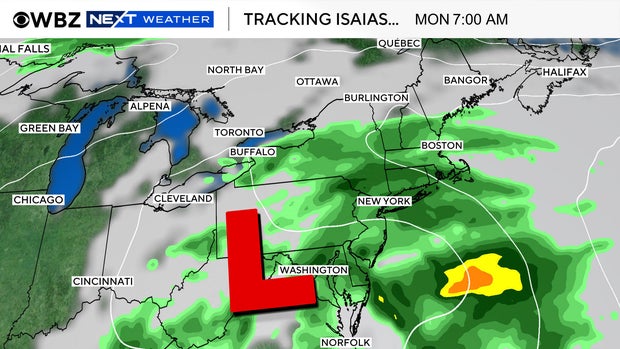
The rain will arrive Sunday night, perhaps around midnight, and linger into the first half of Monday.
Currently, it looks like we may clear out later in the day Monday.
Rainfall totals look light, mainly less than a half inch.
We do not expect any significant wind or other impacts in the Northeast.
Slow huricane season
One last thought: This has been a record slow hurricane season in the Atlantic.
Largely thanks to a very strong El Nino, this is the latest in the season we have gone before the formation of the first hurricane.
The prior record was Sept. 11 set back in 2002 and 2013.
We still may break the record for least hurricanes in a single season (in the satellite era). The current record is two hurricanes back in 1983 and 2013.


