Here We Go Again
BOSTON (CBS) - Clouds along with ocean-effect rain and snowflakes will carry us through this Wednesday. Highs will hover around 40.
Check: Interactive Radar | Current Conditions | Weather Blogs
The storm moves into New England tonight. This storm will be affecting New England through Friday. It will include a plethora of weather conditions...heavy, wet snow inland, heavy rain for the Cape/Islands, damaging winds, and coastal issues.
Read: Ask The Weather Team
Winter Storm Watches will take effect early Thursday morning and continue through Friday morning. Additionally, Coastal Flood Warnings will be in place for 3 high tide cycles 7 a.m. and 7 p.m. Thursday as well as Friday morning's high tide around 8 a.m.
The two morning high tides are the ones we are most concerned about due to the higher astronomical tides. Seas will be reach 25-to-30 feet as well as a storm surge of 2.5-to-3 feet.
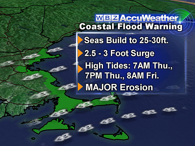
Hence, there will be major erosion and moderate to major coastal flooding during those morning high tides.
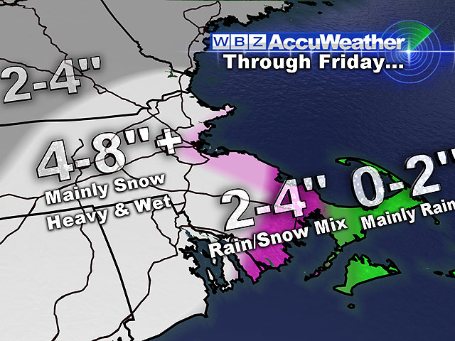
The coast will be dealing with a rain-mix throughout this storm with heavy, wet snow falling away from the coast.
The Cape and Islands will mainly be dealing with more a rain event.
A wide swath of heavy, wet snow adding up to 4-to-8+ inches will fall for most areas away from the immediate coast throughout the 36-to-48 hour event.
Conditions will gradually improve on Friday evening.
This weekend looks wonderful! It's a sure sign of Spring!!!
Saturday will be partly cloudy with highs near 50, while Sunday will be mostly sunny with highs in the lower 50s!
Halfway there...
~Melissa :)


