sFlood watch issued for parts of Massachusetts with torrential rain falling Sunday

The WBZ-TV Weather Team is issuing a NEXT Weather Alert for a flood watch issued for southern Worcester County, Norfolk County and southeast Massachusetts and Rhode Island Sunday, as well as eastern Connecticut. The watch will be in effect from late Saturday night through Sunday afternoon.
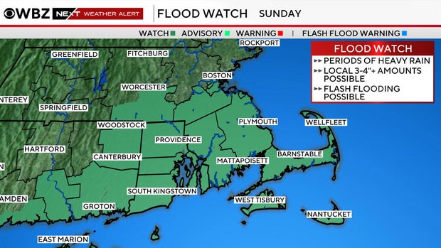
The main concern will be from roughly 7 a.m. through 5 p.m. Sunday, with the greatest potential for heavy rainfall through 3 p.m.
How much rain?
We're expecting periods of showers, along with a few embedded thunderstorms. Most locations should see rainfall totals in the 0.50–2 inch range, but the bigger concern is the potential for localized narrow bands of torrential rain.
If one of these heavier bands develops and stalls over an area, 2 to 4 inches of rain could fall within just 3 hours. That's enough to create localized flash flooding, particularly in vulnerable urban areas where drainage can quickly become overwhelmed.
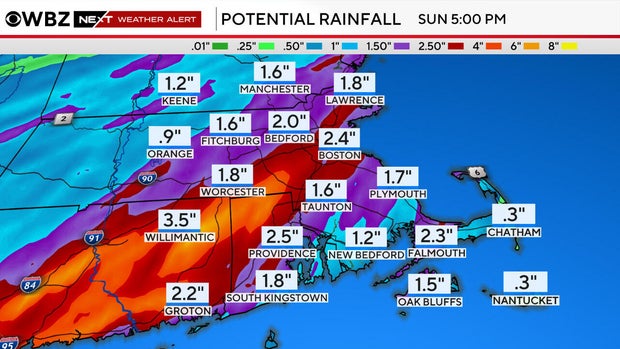
Even though the overall setup isn't necessarily a widespread flooding event, a localized corridor of very heavy rain could cause problems quickly.
If you're heading out Sunday early afternoon, remember to never drive through a flooded roadway; turn around and find another route.
Massachusetts Weather Radar
For now, the focus is on the potential for localized flash flooding within an otherwise fairly wet Sunday, with the greatest concern during the late morning and early afternoon hours. After the line moves through, we'll actually end the day with some sunshine and much calmer conditions.


