Most of our much-needed rain ended up out to sea
By Terry Eliasen, Meteorologist, WBZ-TV Exec. Weather Producer
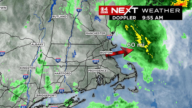
BOSTON -- Our best chance of beneficial rain this week has gone wide right and turned into a storm for the fish. It DID rain Wednesday morning, but unfortunately the downpours occurred about 50-to-70 miles off the coastline. Sure, we could still see a few scattered, light showers near the coastline this afternoon, but the hopes of drought relief have gone up in smoke.
This is a big blow to our hopes of slowing down the drought, and I am sure that the news Thursday morning (when the new drought monitor is released) will only get worse. My guess is we will see the areas of severe and extreme drought expanding once again.
We are now in our sixth straight dry month and approaching 10 inches below the average rainfall to date in Boston.
While most cities and towns now have imposed water bans or restrictions, the good news is that large reservoirs remain in good shape (normal levels).
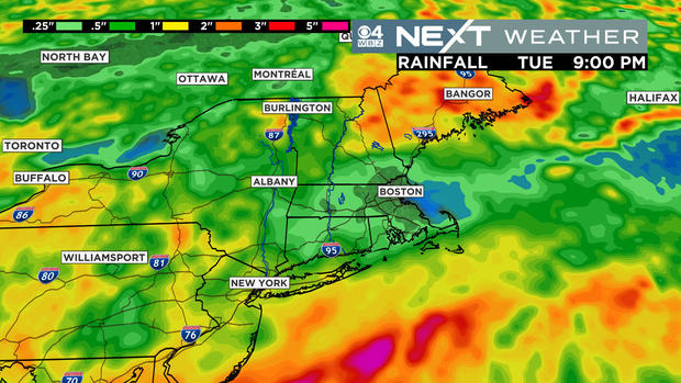
The drought story is NOT going away any time soon. Looking at the projected rainfall in the next week or so, there is very little, if any in southern New England. It feels like there is a force field over top of us. No doubt, it will take some sort of major pattern change or perhaps a tropical system to truly turn things around.
The Atlantic hurricane season has been very quiet thus far, but there are signs that towards the end of August and into September things could ramp up quickly.
As for the next several days, we stay dry and start to warm up again heading into the weekend.