Will it snow in Maryland this year? Meteorologists predict this winter's weather


BALTIMORE -- With another winter season fast approaching, many of you are likely wondering about our chances for snow this season. Compared to last year, which saw record-low snowfall amounts for the entire winter in Baltimore, this year hints at a better chance for some accumulating snow.
With this year's winter showing signs of being markedly different from the last, WJZ First Alert Meteorologists Derek Beasley, Steve Sosna, Meg McNamara, and Tim Williams are predicting how much snow we can expect this winter, the temperatures we might see, and the variety of severe weather that could impact the region.
How much snow are we getting?
Chief Meteorologist Derek Beasley
There are two main things needed to get wintry weather: cold enough air and a moisture source. Both need to be present at the same time to create the potential for wintry weather.
To get the cold air, the jet stream needs to be configured in a way that brings the cold air southward. At the same time, a moisture source needs to transport the moisture into our area to bring the chance for snow.
Last year's winter was dominated by above-average temperatures and snowfall that was well below average. In fact, it was Baltimore's least snowy winter on record. 0.2 inches of snow were recorded on February 1 at BWI, which was the only measurable snow for the entire season. Baltimore typically sees an average of about 20 inches of snow per year.
The main influence from last year was a La Niña pattern (ENSO positive), which led to unseasonably warm weather, especially for the latter portion of winter. La Niña is the cooling of the waters in the equatorial Pacific, which leads to an altered jet stream pattern around the globe.
This year is showing signs of being markedly different. Over the spring and summer, we began transitioning from a La Niña pattern to what is likely to become a strong El Niño (ENSO negative) heading into the heart of winter.
This pattern, which occurs when the waters in the equatorial Pacific Ocean are warmer than average, leads to an active subtropical jet stream that is suppressed across the southern United States. This pattern leads to wet conditions across the southern United States, an elevated severe weather threat on the Gulf Coast, and drier-than-normal conditions for the Ohio Valley.
Typically, ENSO-negative winters lead to higher chances for accumulating snowfall events in the Baltimore area.
The real sweet spot for significant snow during an El Niño winter in the Mid-Atlantic is when it is a moderate one, rather than a strong one, like the one we are transitioning toward. From 1950 to 2016, 4 of 7 strong El Niño winters experienced above-average snowfall.
Moderate El Niño winters produced 5 of 8 above-average snowfalls. Interestingly, during moderate El Niño winters, temperatures were mostly below average, while during winters with a strong El Niño, temperatures were often above average (5 out of 7, to be exact).
The main takeaway here is that when looking at El Niño alone to determine the likelihood of significant snowfall in the Mid-Atlantic, we typically see more snow during moderate and strong El Niño episodes.
Furthermore, moderate El Niño events tend to produce higher chances of above-normal snowfall for our area than strong El Niño events, likely due to the transport of warmer air northward.
What kind of weather could we get?
Meteorologist Steve Sosna
While winter officially arrives December 21, 2023 at 10:27 p.m., winter weather in the form of snow and/or ice can arrive as early as October in Maryland.
In fact, winter weather is possible anytime from October through May across Maryland, but the most common months for it are December through March.
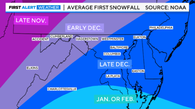
On average, our first inch of snowfall in and around Baltimore usually takes place in late December. Across central and western Maryland the first inch is usually measured by early December. Finally, in extreme western Maryland, in the mountains, places like Accident and Oakland typically pick up their first inch of snow by late November.
When people think of winter in Maryland, they typically think about snow! And while our winter weather certainly does come in the form of snow, it can also come as sleet and freezing rain. Any of these forms of winter precipitation can cause severe to major travel disruptions, school delays and closings, and even power outages in some cases.
The atmosphere is like a cake. Like a layer cake, which may have different flavors, the atmosphere can have different temperatures at different heights. This leads to the different types of precipitation that we receive during our colder months.
To understand the different forms of winter precipitation, it's important to understand the different temperature profiles of the atmosphere associated with them.
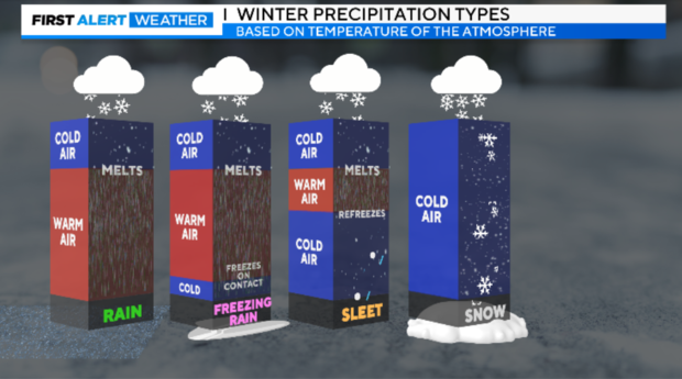
With all four types of precipitation, rain, freezing rain, sleet, and snow, the precipitation usually begins as snow up at the cloud level.
With rain, the snowflakes usually quickly melt into rain droplets, with a deep layer of warmer air (above 32 degrees) from the melting point of the snowflakes down to the ground.
When we experience freezing rain, one of the most dangerous forms of winter weather, snowflakes melt into rain droplets during their journey to the ground. However, right before the raindrop is about to make contact with the ground, the raindrop encounters air temperatures at 32 degrees or below. This allows the raindrop to freeze upon contact and turn into ice. This is known as freezing rain.
The reason why freezing rain is so problematic is because it accumulates as ice. Once you reach ¼" of ice accumulation, you can have tree limbs snapping, power outages, and dangerous driving conditions. During some of our worst freezing rain events, we've seen accumulations of ice greater than an inch. These come in the form of paralyzing ice storms.
When we experience sleet, snowflakes melt into raindrops beneath the cloud layer, however, the raindrops encounter another colder layer in the atmosphere on their journey down to the ground. This causes the raindrop to refreeze into an ice pellet. This ice pellet then falls to the ground.
Sleet, or ice pellets, usually bounce when they hit the ground. While sleet is a form of ice, it tends to be much less dangerous than freezing rain, as there is a bit of traction you can get when sleet accumulates. Sleet is notorious for cutting down on snowfall accumulations during big storms.
This happens when a mid-level layer of warmer sneaks into the atmosphere. This typically happens during some of our bigger winter storms.
Finally, snow! Snow falls when the entire atmosphere is near or below 32 degrees from the cloud all the way to the ground, this allows for the snowflakes to stay intact all of the way to the ground.
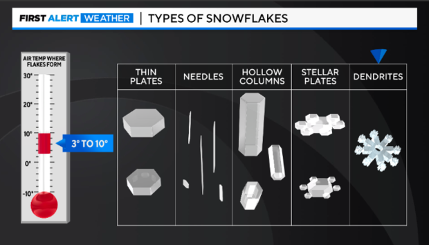
Believe it or not, there are different types or classifications of snowflakes. The different types of snowflakes are caused by different temperatures in the cloud layer. The type of snowflakes that cause the biggest accumulations tend to be dendrites, due to their larger surface area. They can stack up quickly causing larger accumulations!
Here are the different types of snowflakes based on the temperature in the cloud layer where they form.
Thin Plates:
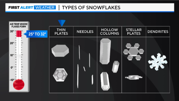
Needles:
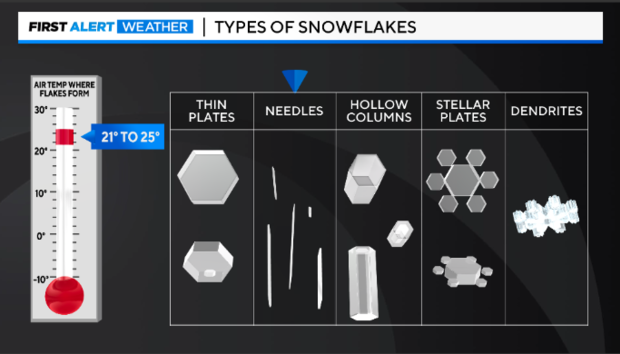
Hollow Columns:
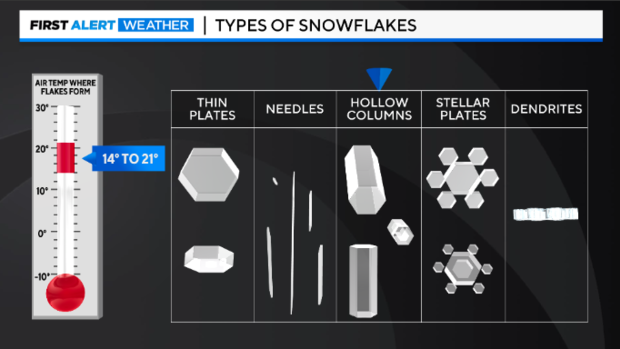
Stellar Plates:
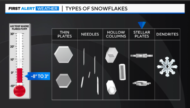
Dendrites:
Our Temperature Outlook
Meteorologist Meg McNamara
As we look ahead to winter and wonder what kind of season we're in for, temperatures will play a crucial role.
After all, a difference of a degree or two determines if we see rain, snow, or the dreaded wintry mix!
Winter arrives on Dec 21 and in the weeks leading up to the new season, NOAA's temperature outlook shows equal chances for above and below-normal temperatures.
That changes though in their predictions temperatures for December, January, and February. Those three months as a whole are leaning above normal in Maryland.
The normal temperature for December in Maryland is 38.6°, 34.3° for January, and 36.6° for February. Last winter, December ran a tad cooler, with an average temperature of 37.5°.
The beginning of 2023 was significantly milder than normal with temperatures averaging 43.9° in January and 44.7° in February.
If you recall, those warm temperatures left Baltimore with its least snowy winter on record!
We picked up two-tenths of an inch one day in February, and that was it!
Now even though temperatures seem to be leaning milder over the next few months, there are also expected to be a few cold snaps.
And we know all it would take is precipitation to line up with one of those shots of cold air and we could get a significant winter weather event.
Energy Use vs. Winter Temps
Meteorologist Tim Williams
One of the biggest impacts on your electricity or natural gas usage is how well your home's heating system, insulation, and weather proofing can combat the impending Winter chill and ensuing Polar Vortex.
Understanding the impacts and thresholds of cold can help equip you for the season. Certainly, every family's comfort level is different but, following these quick tips to reduce energy consumption and still keep warm.
Keep in mind a few basics. When the temperature goes down, reducing your electricity usage is an excellent way to keep your bills down by resisting the urge to turn up the heater and turn the thermostat down a few degrees.
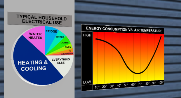
Each degree you reduce may save you 2% on your heating costs. Grab a sweater and some warm socks instead. If you head out of town for a few days, you can drop it down to 55°. But don't shut it off entirely to avoid returning home to frozen pipes.
The magic number, if you can physically adjust, is a constant thermostat set at 68°.
- Check your thermostat settings. Try turning down your thermostat temperature as much as possible. For every degree above 68°, you can expect a 3% to 5% increase in your heating costs compared to lower settings.
- Bundle up. Reach for a sweater or blanket before reaching for the thermostat. Weather-appropriate clothes can help you keep your heater at a lower setting and stay comfortable.
- Let the sun in. Open blinds and shades during the day and remove any solar screens so the sun can warm your home.
- Keep your HVAC fan at "auto." Set your HVAC to "auto." Your system will run 24/7 if it's set to "on" and increase your bill.
- Set your thermostat lower when you're away. Set your thermostat to 50° when you're away. This is warm enough to prevent your pipes from freezing without wasting energy on an empty home.
- Use an electric blanket instead of turning on the heater.
- Set your water heater to 120°. This is hot enough to be sanitary while saving you up to $60 a year on your water heating bill.
- Seal up the drafts. If you feel air coming in along windows or doors, replace the weather stripping or use caulk or other draft-reduction tools to keep the warm air in and cold air out.
- Use a portable space heater if you reduce your thermostat but still want to warm up a small room. They're small and efficient — most space heaters use around 1,500 watts of electricity... electric furnaces can use ten times more.
- Draw the curtains and shut the blinds. Covering your windows can reduce heat loss through the windows.


