Will Tropical Depression Edouard impact North Texas and the DFW area? A look at its path.


Will Tropical Depression Edouard impact North Texas? The short answer is "Yes."
Edouard made landfall near Johnson Bayou, Louisiana at 2:20 p.m. CT with maximum sustained winds of 60 mph. Edouard will weaken rapidly now that the center is over land, but the circulation and its deep tropical moisture will continue moving inland. That moisture will spread north and west into portions of North Texas tonight through Wednesday and Thursday.
A flood watch is in effect for Anderson and Freestone counties from late Tuesday night through Wednesday evening as tropical moisture from Edouard moves north.
For most of North Texas, this is not a tropical event. The main impacts will be increasing cloud cover, higher humidity, isolated rain, with thunderstorms for some areas, and lower afternoon temperatures where clouds and rain are more widespread.
The important caveat: not everyone in North Texas will get rain. Most will not. The best opportunity will be south and east of the metroplex.
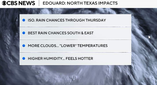
As moisture increases ahead of Edouard's remnants, a few isolated showers or thunderstorms could develop late Tuesday afternoon or early evening. Overall coverage remains very low, around 10%, so most locations stay dry through the evening.
Tropical moisture continues increasing overnight as Edouard's remnant circulation moves farther inland. Rain should begin increasing across our southeastern counties late tonight, while the Metroplex has a much lower, more isolated opportunity for rainfall.
Noticeable temperature difference across North Texas on Wednesday
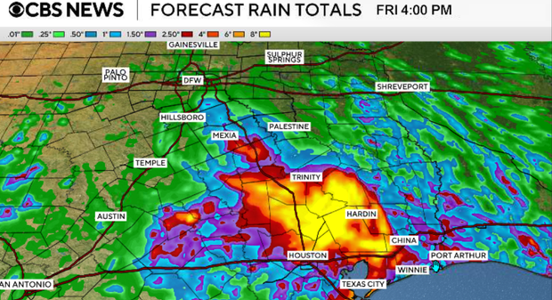
Wednesday is when we'll begin seeing a greater influence from Edouard's remnants. Rain will expand northward, particularly along and east of I-45 and south of I-20. These areas have the best opportunity for beneficial rainfall.
Because the atmosphere will contain very deep tropical moisture, any heavier showers or storms will be capable of producing efficient rainfall rates, meaning quite a bit of rain could fall in a relatively short period of time. Farther west and northwest, including areas west of I-35 and north of I-20, rain will be considerably less widespread, and temperatures will remain hotter.
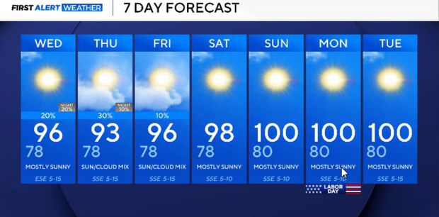
That creates a noticeable temperature difference across North Texas on Wednesday. Areas with more clouds and rain should stay in the low to mid-90s, while locations farther west and northwest could still climb into the upper 90s or near 100°.
Additional pockets of rain and thunderstorms will remain possible Wednesday night as Edouard's remnant circulation continues influencing the region. Where multiple rounds of rain occur, localized flooding could become a concern, especially across our far eastern and southeastern counties.
Thursday
Scattered showers continue Thursday, mainly east of I-35, but coverage should gradually decrease by Thursday evening. A few pockets of moderate rain or isolated thunderstorms remain possible during the afternoon.
For DFW, this means there is still an opportunity for some isolated beneficial rainfall, but the metroplex is not positioned beneath the axis of heaviest rain from Edouard, which lies in our southeastern counties.
Friday and the weekend
Edouard's influence begins to fade as we finish the workweek. The upper-level ridge to our east will expand back toward the Southern Plains Friday into the weekend. That means most of North Texas returns to a predominantly dry pattern. Unfortunately, the heat comes back with it. Highs climb into the upper 90s to near 100° by Saturday and Sunday, and lingering moisture could push heat index values back toward 105° this weekend into early next week.
Fire weather
The areas that miss out on Edouard's rainfall will continue dealing with very dry vegetation and elevated fire-weather concerns. This will be particularly important across our western counties, where rainfall from Edouard will be minimal or nonexistent and hot temperatures continue.