Latest snow storm forecast maps show fresh predictions for where winter weather will hit hardest
As millions of Americans hunker down for a massive winter storm sweeping the country, new maps are offering updated forecasts of snow and ice accumulations.
More than 200 million people were under winter storm threats at the height of the impact. Sleet and freezing rain moving across 35 states created dangerous conditions through the weekend, and the storm will linger in the New England region through Monday morning before finally exiting the U.S. later in the day.
Twenty-three states and Washington, D.C., declared states of emergency, and at least 10 states have activated their National Guards as the sprawling weather system began to move across land.
States of emergency were declared in Alabama, Arkansas, Connecticut, D.C., Delaware, Georgia, Indiana, Kansas, Kentucky, Louisiana, Maryland, Mississippi, Missouri, Nebraska, New Jersey, New York, North Carolina, Ohio, Pennsylvania, South Carolina, Tennessee, Texas, Virginia and West Virginia.
"It's the largest storm that we've seen impact the most states in this big of a population in possibly decades," Homeland Security Secretary Kristi Noem said at a news conference.
FEMA officials said they have several distribution centers across the south and east stocked with over 7 million meals, more than 3 million liters of water, over 650,000 blankets and more than 180 generators.
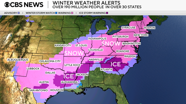
Forecasters also warned of frigid temperatures, gusty winds and dangerous wind chills. Areas at the center of the storm, including parts of Kentucky and Virginia, could see as much as 2 feet of snow between Saturday and Monday.
Major cities, including New York City, Boston and Oklahoma City, could see as much as 12 to 18 inches of snow. The outer bands of the storm could bring between 1 and 6 inches to large swaths of the country.
New York City Mayor Zohran Mamdani said the city was forecast to face the coldest sustained temperatures it had seen in eight years. He also announced the deaths of at least five New Yorkers on Saturday, writing in a social media post that it was too early to officially determine what caused the fatalities but calling them "a reminder that every year New Yorkers succumb to the cold."
"The danger of this weather cannot be overstated," Mamdani said.
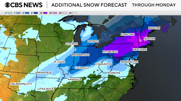
Maps show winter storm forecast
This map shows the storm system spanning from New Mexico and Texas to the Northeast, with parts of many states forecast to see 12 inches of snow or more. Additional snow totals upwards of 12 to 18 inches are possible across parts of the New England region.
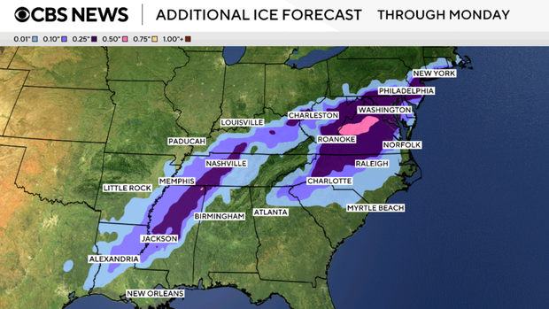
The southern part of the country will see accumulations of both ice and snow. Ice accumulations can be more dangerous than snow, officials warned. The weight of ice on power lines is more likely to cause outages. It is also harder to clear than snow and can make for dangerous driving conditions.
"Once we get more than about a quarter inch of ice on those lines, the lines either start sagging and failing, or more likely, you actually get the vegetation above it, the trees, to fall on the lines, and that causes potentially a larger number of outages," said Thomas Overbye, a professor of electrical and computer engineering at Texas A&M University.
Ice accumulations of up to 1 inch were forecast for spots of the South. Parts of Texas, Georgia, Arkansas, Mississippi, Alabama and Tennessee might see up to .75 of an inch of ice. Areas along the outer bands of the storm are expected to see up to a half inch. Ice storm warnings remain in effect across parts of the Southeast through Monday afternoon.
The clear message from state leaders to residents was stay home and don't drive, but already dozens of drivers have slid off the roads.
Nashville city transportation officials only have 45 snow plows to clear hundreds of miles of roads. But once the storm shifts from snow to sleet, the plows may not help.
On Saturday evening, icy conditions began accumulating in Tupelo, Mississippi, with a layer of ice blanketing the city.
"Catastrophic impacts are expected where freezing rain amounts exceed a half inch, with over one inch totals possible in parts of northern Louisiana, central and northern Mississippi, southern Tennessee, and the southern Appalachians," the National Weather Service says.
Freezing temperatures are compounding the storm's effects. Snow that melts can quickly turn to ice. Wind chills are quickly bringing the mercury into the negatives.
"If it gets out ahead of us and it becomes snow packed, solid sheets of ice, we get down into single digits — not a lot you can do," Justin Pierce, a plow driver with the Nashville Department of Transportation, told "CBS Saturday Morning."
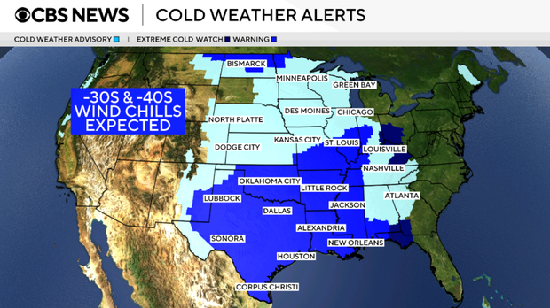
Over 71 million people were under an extreme cold warning Sunday night, which means temperatures or wind chills are forecast to fall below 5 degrees Fahrenheit over the next 12 to 24 hours. Over 9 million people are under an extreme cold watch, which means those conditions are expected in the next 24 to 48 hours.
More than 87 million people are under a cold weather advisory, which the weather service said is issued when either temperatures or wind chills are expected to fall to or below 15 degrees but remain about 5 degrees Fahrenheit.
Significant cold temperatures are expected to stick around after the storm moves out, meaning power outages may result in dangerous indoor temperatures.
"In the wake of the storm, communities from the Southern Plains to the Northeast will contend with bitterly cold temperatures and dangerously cold wind chills," the weather service says. "This will cause prolonged hazardous travel and infrastructure impacts."


