First Alert Weather Day for North Texas with Tuesday evening storm chances


A First Alert Weather Day is in effect for Tuesday evening until 10 p.m. due to the potential for strong to severe storms across North Texas (30%).
We are also watching the potential for scattered showers and thunderstorms Sunday into Monday as another disturbance approaches North Texas. Confidence in timing and coverage is still somewhat low, but it does appear the second half of the weekend could turn a bit more unsettled.
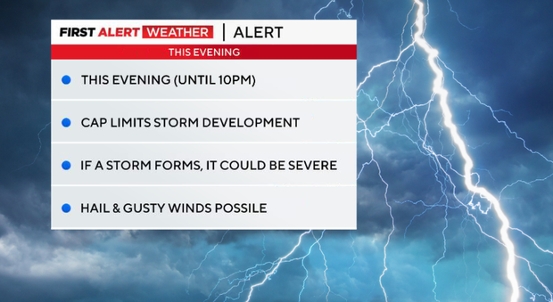
A cold front will move into North Texas Tuesday evening, bringing a 20–35% chance of storms. A cap is in place across much of DFW, which will limit storm development. However, as the front moves in, we could see isolated storms develop, mainly east of the metroplex.
Timing: Chance of storms until 10 p.m.
If storms develop, they could produce large hail and damaging winds. Most areas stay dry, but this is a stay-weather-aware evening, especially in areas east of Dallas-Fort Worth.
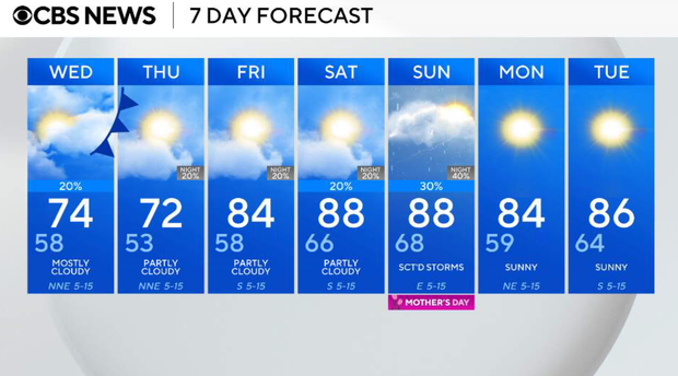
Cool and cloudy on Wednesday
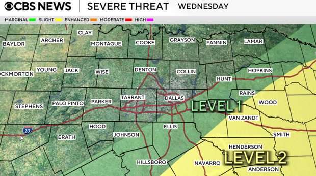
Behind the front, expect cooler temperatures and more cloud cover. Highs will be in the low to mid-70s, with a small chance of a passing shower in the metroplex. We could still see a strong storm or two in our southeastern counties. Henderson, Anderson, Van Zandt, Navarro, Wood and Smith counties are under a Level 2 risk.
Thursday will be partly cloudy to mostly sunny and cooler than normal. Highs remain in the 70s, with a light north breeze.
Friday will be another quiet and comfortable day. Temperatures warm back to the 80s with a light south wind.
Looking ahead to Mother's Day weekend
After a cooler end to the workweek, we'll gradually warm back up heading into Mother's Day weekend as southerly winds return and humidity begins to increase again.
At the same time, we'll be watching the potential for scattered showers and thunderstorms late Sunday into Monday as another disturbance approaches North Texas. Confidence in timing and coverage is still somewhat low, but it does appear the second half of the weekend could turn a bit more unsettled.