Breezy, humid and hot for North Texas before end-of-week cold front


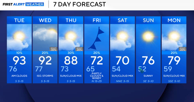
A significant change in our weather pattern is developing this week. Strong southerly winds will transport Gulf moisture into North Texas, bringing increasingly humid conditions and temperatures well above average for mid-October. Highs in the lower 90s on Tuesday and Wednesday could feel closer to 100°. Isolated thunderstorms will be possible midweek as a western upper-level trough approaches and a cold front moves through Friday. Behind the front, much cooler and drier air will arrive just in time for the weekend.
Monday evening will be partly sunny, breezy, and increasingly humid. Temperatures will climb to around 90° in DFW, approximately 10 degrees above our seasonal average.
With increasing Gulf moisture, heat index values could reach the middle 90s. South winds will become gusty, occasionally reaching 25 mph. A few isolated showers or thunderstorms may develop during peak afternoon heating, primarily near and south of I-20. Coverage will be limited, and most locations will remain dry.
Any storms that develop should be brief and remain below severe limits. Rain chances diminish after sunset.
Warm and muggy conditions will continue overnight. Southerly winds will ease somewhat, but Gulf moisture will continue increasing. More low clouds are expected to develop, helping keep temperatures elevated. Overnight lows will generally range from the upper 60s to the middle 70s, with the warmest readings around the Metroplex.
Expect high temperatures on Tuesday
Tuesday will likely be one of the most uncomfortable days of the week. Temperatures will climb into the lower 90s, with DFW around 93°. Dew points could remain in the lower to middle 70s even during the afternoon. That combination could produce heat index values around 100°, with some locations potentially exceeding that mark.
Expect a mixture of clouds and sunshine, breezy south winds and very humid conditions. An isolated afternoon shower or thunderstorm is possible, with the better chances generally south of I-20. Most of North Texas will remain dry.
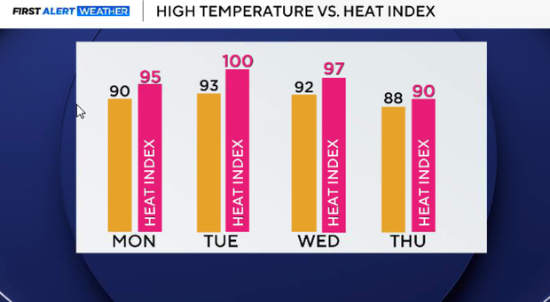
There will be little relief from the heat on Wednesday. Highs will again reach the lower 90s, with heat index values potentially approaching 100°. The western upper-level trough will begin influencing our weather, but the stronger lift and more substantial rainfall signal will remain northwest of North Texas. Warm air advection and daytime heating may support isolated showers and thunderstorms. Rain chances increase slightly (20%), but widespread rainfall is not expected.
Chance of showers, thunderstorms increases Thursday
Our weather pattern becomes more unsettled as the upper-level trough advances eastward.
Temperatures remain warm, and humidity stays elevated, with highs generally in the upper 80s to near 90°. Shower and thunderstorm chances should gradually increase, especially across western and northwestern North Texas later in the day and Thursday night. However, the exact timing and coverage remain uncertain because the evolution of the western trough is still complicated. Right now, we only have a 30% for most of North Texas.
Cold front expected in North Texas on Friday
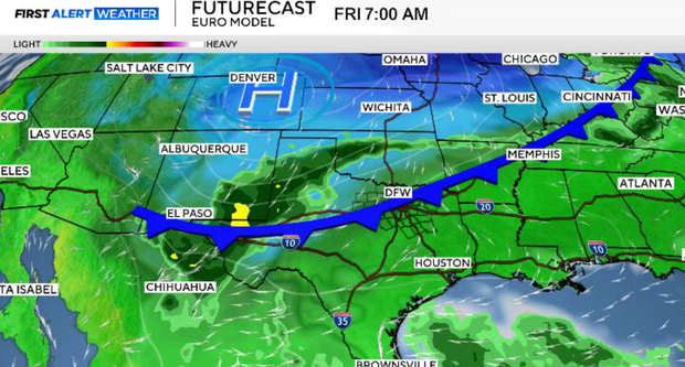
This is our primary transition day. A cold front is expected to move south through North Texas sometime Friday, bringing additional opportunities for showers and thunderstorms.
The timing of the front will determine how warm we get and when the rain chances begin to diminish. Behind the front, northerly winds will usher in much cooler and drier air, with improving conditions expected from north to south.
Expect a completely different feel for the weekend.
Afternoon temperatures should top out in the 70s, compared to the lower 90s earlier in the week. Morning lows will fall into the 50s, and lower humidity will make conditions much more comfortable. The weekend is shaping up to feel much more like October, with refreshing mornings and pleasant afternoons.