Hot North Texas weather persists into September


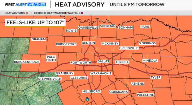
A heat advisory remains in effect through 8 p.m. Wednesday for much of North Texas. Heat index values could reach 105–107° on Wednesday afternoon.
The September heat continues, and DFW is moving higher on a couple of notable lists. With temperatures forecast to reach 101–102° Tuesday, this would become our 44th day at or above 100° this year, moving 2026 into ninth place (tied with 1952) for the most triple-digit days in a year. It would also give us seven 100° days already this September. The September record is 8, so we could tie or break it later this week.
Assuming DFW remains dry today, our stretch without measurable rainfall will reach 55 consecutive days, making this the sixth-longest dry stretch on record.
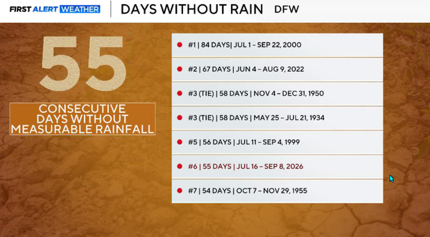
Unfortunately, the small rain chances showing up this week do not look sufficient to change the larger drought picture. Coverage will generally be only 10–20%, meaning some neighborhoods may get a thunderstorm while many locations could go the entire week without seeing a drop.
Tuesday night in North Texas
Another very hot evening with temperatures reaching the upper 90s to lower 100s. Humidity will make it feel even hotter, with heat index values potentially reaching 105–108°.
A weak disturbance moving in from the east will provide a small opportunity for isolated showers and thunderstorms late this afternoon and early evening in our eastern counties.
Most of North Texas will remain dry. Widespread severe weather is not expected, but any isolated storm that develops could produce a quick downburst with wind gusts potentially exceeding 50 mph. Any showers or storms should fade after sunset as we lose daytime heating.
Temperatures will fall into the mid and upper 70s, with some locations potentially remaining near 80°.
Heat advisory continues
A heat advisory will be in effect through 8 p.m. Wednesday for much of North Texas. The weak disturbance responsible for Tuesday's isolated storms continues moving westward, shifting the small rain opportunity toward our southwestern counties. Coverage remains very low, around 10%, so most of North Texas will once again remain dry. Temperatures stay well above normal, generally reaching the upper 90s to around 100°, with heat index values potentially approaching 105° again.
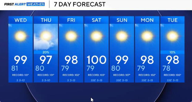
Thursday, a weak frontal boundary will sag south toward North Texas as the upper-level ridge flattens slightly. This could provide another opportunity for isolated showers and thunderstorms, particularly near the Red River and across northern North Texas. Rain coverage may increase to around 20%, but this still does not look like widespread or drought-relieving rainfall.
Additional cloud cover could knock temperatures down a few degrees in some locations, but this is not a strong cold front, and no significant cooldown is expected.
Friday and this weekend, the ridge remains a dominant feature and the late-summer heat continues. Highs will generally remain in the upper 90s to around 100° through the weekend, keeping temperatures well above normal for September. There could occasionally be enough moisture for an isolated shower or thunderstorm, but most locations will remain dry.
Looking ahead
There are some indications that the overall pattern could become a little more active toward the middle of next week, but confidence remains low this far out. For now, there is no widespread soaking rain or significant cold front in sight, meaning both the heat and drought remain our primary weather stories.