Rain chances and high pressure build as temperatures rise in North Texas


Flooding concerns continue in far northeast North Texas on Tuesday. Repeated thunderstorms produced 6 to 8 inches of rainfall in parts of Lamar and Red River counties over the past 24 hours, resulting in numerous reports of flash flooding.
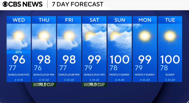
Rain chances will fade overnight as high pressure builds across Texas. Temperatures will steadily climb through the remainder of the week, with highs approaching 100 degrees by the weekend and heat advisories becoming increasingly possible.
Tuesday evening and night
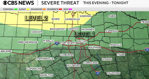
A few additional showers and thunderstorms may develop near the Red River overnight. Some of the storms could drop down into some of our northern counties.
Cooke, Montague, Grayson, and the northern areas of Denton and Wise counties are under a level 2 risk. Dallas-Fort Worth has a level 1 risk. Any storms that form could produce brief heavy rainfall, gusty winds and frequent lightning.
Low temperatures will remain warm and humid, falling only into the upper 70s.
Wednesday
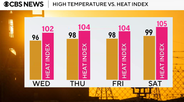
Most locations will remain dry with increasing sunshine. High temperatures climb into the mid to upper 90s with heat index values again topping 100 degrees.
Thursday and Friday
High pressure continues building across Texas. Rain chances end, and temperatures continue climbing, with highs reaching the upper 90s. Weekend heat begins to take shape as humidity remains elevated.
Looking ahead
The hottest weather of the season so far is expected this weekend into early next week.
Many locations will reach the upper 90s to near 100 degrees, while heat index values climb above 100 degrees each afternoon. Heat advisories may become necessary in portions of North Texas.