Fantastic weekend weather for North Texas ahead of major warm-up, returning storm chances

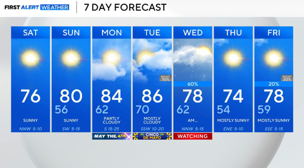
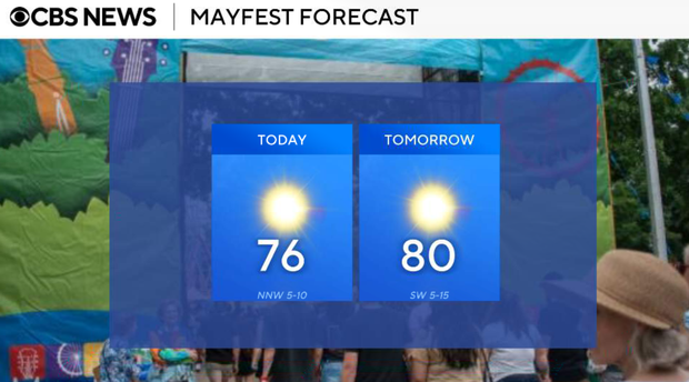
North Texas started Saturday with a cool and crisp feel, with temperatures in the upper 40s to low 50s. This is all thanks to a post-frontal airmass and high pressure settling in, bringing in much drier air (courtesy of dewpoints in the 40s and 50s). That dry air not only helped limit rainfall yesterday, but it's also setting us up for a really comfortable weekend. Cloud cover will continue to thin out through the morning, giving way to mostly sunny skies by the afternoon. Highs today will reach the mid 70s, with light north winds and low humidity making it feel fantastic.
Saturday night will see clear and calm conditions, which will allow temperatures to drop once again. Lows fall into the upper 40s to low 50s, with just a very low chance for some patchy shallow fog early, but nothing widespread.
Sunday is another beautiful day. We'll start in the 50s, then warm into the upper 70s to near 80 by the afternoon. As winds begin to turn out of the south, we'll start to see a gradual return of moisture, but humidity will still feel comfortable.
To kick off the coming week, Monday will see a noticeable warm-up begin. Stronger southerly flow brings Gulf moisture back, with dewpoints climbing and highs reaching the mid to upper 80s. It will feel warmer and a bit more humid, but still dry overall. Windy. South wind 10 to 15 mph, with gusts as high as 30 mph.
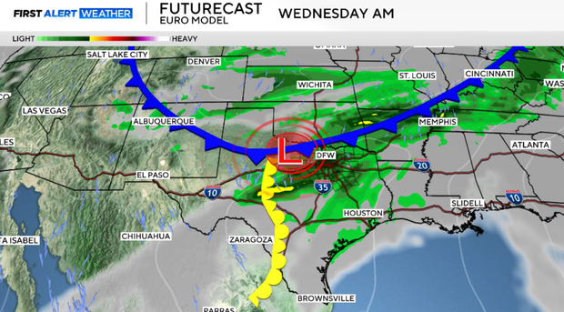
Tuesday will be the warmest day of the stretch, with highs pushing the upper 80s. We'll be watching a cold front and possible dryline interaction developing late in the day. This could bring scattered storms Tuesday night into Wednesday morning and afternoon. This is the main window to watch for our next round of storms.
While the setup is not perfect, any storms that do develop will be in an environment supportive of strong to possibly severe weather, including gusty winds & hail.
Storms may organize quickly into a line along the front, which could limit how widespread activity becomes, but it's still something we'll be watching closely.
Behind the front, we'll see a brief cooldown, with highs dropping back below normal. The second half of the week is trending drier and quieter.