Heat advisory, rain chances continue for North Texas

NORTH TEXAS (CBSNewsTexas.com) - A heat advisory is now in effect from Sunday at 1:00 p.m. to Monday at 9:00 p.m. for the southern portion of North Texas.

The DFW Airport received 0.12" of rain, the first measurable rain this month and the most in over two weeks.

Rain chances are in the forecast for a couple more days, including small chances Sunday night and early Monday but better chances arrive Tuesday morning. Storms from the Panhandle will take the overnight highway to North Texas, arriving just around morning commute time.

On Monday and Tuesday, we will have high pressure to the west, driving the high plains storms southeast toward us. They weaken overnight, meaning rain chances will be spotty and severe chances stay low.
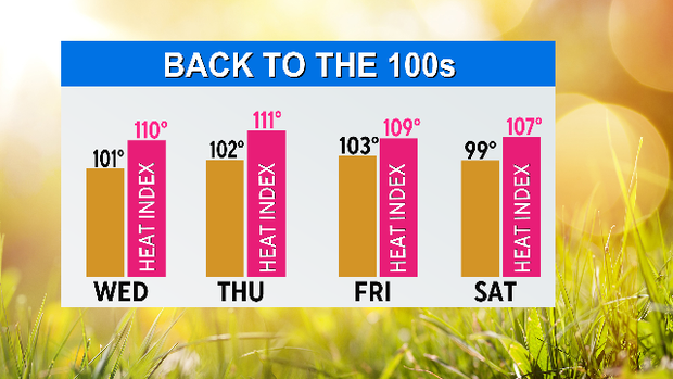
This is the time of year when the ridge to the west frequently expands east and sticks for a spell. This moves the storm track to the deep south and cuts us off from rain chances. With the high pressure, the sunshine and the proximity to the (historically) warm Gulf of Mexico bringing high humidity, we jump right into a new streak of 100-degree days and dangerous heat indices.
There is a recent development in the extended forecast that suggests a bit of a break in the heat for Saturday through Monday. It includes modest rain chances by Sunday if there is a northwest flow that delivers storms overnight.