Fire Continues To Be The Big Story This Weekend, But Rain & Ice Are On The Horizon
FORT WORTH (CBSDFW.COM) - In the words of James Taylor: "I've seen fire and I've seen rain" - and maybe some ice. All three could be issues this week.
Greetings and salutations! In the words of Gomer Pyle: "Well Go-o-o-ollee!" or "Surprise, surprise, surprise." It's another day of beautiful, comfortable weather. Fire continues to be the big story this weekend but then things take a turn. I've got some severe weather and some winter weather potential and much colder temperatures all in the days ahead.
SUNDAY:
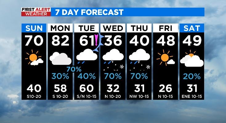
You'll notice a stark increase in clouds, especially by late afternoon. But fear not. I'll still be a ray of sunshine in your life. Aww. It'll be a mild day with temps moving up near 70.
MONDAY:
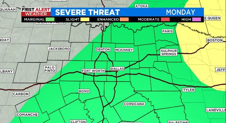
Cloudy skies will dominate with a small chance of rain in the afternoon. Highs hit the LOW 80s! Unbelievable. By Monday evening, some of the showers are possible but stronger storms will be possible late as deeper moisture flows in. Given the strong capping inversion in place (think lid on a pot of potatoes keeping the steam from escaping) the cap may prevent severe storms but nonetheless, the SPC has a marginal chance of severe weather. I don't think it'll amount to much, but we'll watch it.
TUESDAY:
Old Man Winter arrives. Temps start warm and gets cold quick by the afternoon. So morning crew, you may show up to work in short sleeves but definitely have jackets. You'll need them by afternoon. The front is expected to come through dry.
WEDNESDAY & THURSDAY:
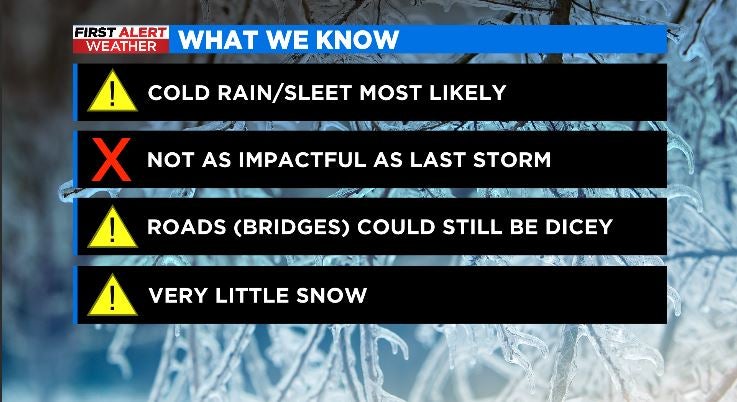
All of North Texas will likely start as cold rain. The further north and west you are of the metroplex the more likely it is to see the rain transition to sleet and freezing rain. Models remain all over the place but when you look at the ensemble members, they've been remarkably consistent in bringing wintry weather all the way through the metroplex Wednesday night and Thursday.
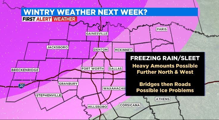
This airmass doesn't look nearly as cold as what we had a few weeks ago. Temperatures are borderline at best--more conducive of producing icing on cars and trees instead of surface streets. HOWEVER, bridges and overpasses are likely to be dicey Wednesday night and Thursday. Thursday night and Friday morning.
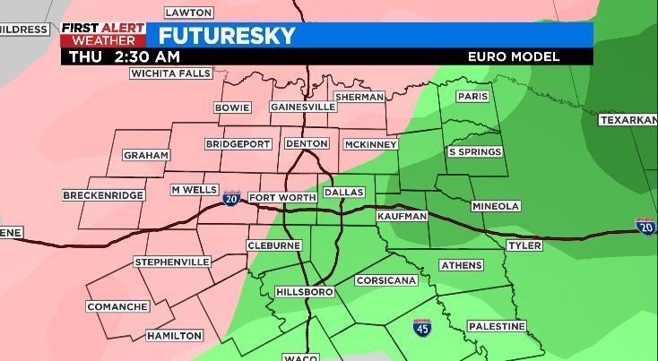
Accumulations of ice look very minor in the immediate metroplex with almost no accumulations for areas southeast of here. However, a negligible amount of ice is just as dangerous as an inch of ice--I'd argue even more dangerous because the roads just look wet instead of white.
Since this is such a borderline event, if the temperatures are just two or three degrees warmer than forecast, it's all rain. The end. If the temps are just two or three degrees colder than forecast, we've got a winter storm on our hands. We'll need to watch carefully.
SO LET'S REVIEW:
- Wintry weather is possible area wide Wed/Thurs.
- Best chance of accumulating ice is northwest, outside the immediate metroplex
- Minor ice accumulations on bridges and overpasses INSIDE the Metroplex is likely making for hazardous travel Wed night and Thursday
- This looks to be strictly an ice event with little or no snow--not even northwest of the metroplex
- This is a borderline event in which 2 or 3 degrees is the difference in all rain or a winter storm.
- Currently, this does not look to be as severe as the storm two weeks ago.
- Stay tuned to Channel 11 and the First Alert Weather Team for the very latest, most up-to-date, accurate, precise, exact, spot on, credible forecast with over 100+ years of collective expertise unmatched anywhere in the market. BOOM.
Heading into the weekend, brief clearing on Friday before clouds and small rain chances return Saturday.
Blake, the meteorologist.
FUN FACTS ABOUT SNOWFLAKES:
- Individual snowflakes are also called dendrites
- The crystalline structure of the dendrite is determined on the temperature as it falls through the atmosphere.
- Snowflakes come in all shapes and sizes, not just the typical star-shaped ones. They can be needles, plates, hallow columns and stellar plates. Partially melted snowflakes that freeze on sleet pellets are called graupel--which looks like a white fluffy ball.
- Finally: the THEORETICAL warmest temperature it can snow is... 51 degrees! Stunning, right? It would take an exceptional set of circumstances like a relative humidity of 1% or less. Snowflakes can survive a 1,000 foot fall in air above freezing before melting. I read one time that in the 1970s, it snowed in Jacksonville, Florida with a temperature of 53 degrees. A burst of rain occurred in an extremely dry atmosphere which caused evaporative cooling allowing for the rain to briefly change to snow. AND now you know...