North Texas to stay hot, breezy through the weekend with low rain and storm chances

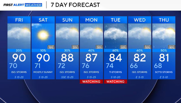
Another hot day is ahead for North Texas. After Wednesday's high of 91 at DFW, highs are expected around 92 Thursday afternoon, with partly to mostly sunny skies and more high clouds filtering in compared to Wednesday.
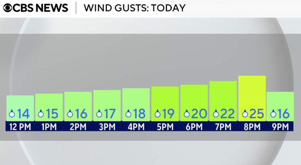
South winds will also increase through the afternoon, becoming breezy at 15 to 25 mph with wind gusts over 20 mph possible.
Thursday night will be warm and breezy, with lows falling into the upper 60s to lower 70s.
Friday will be a more humid and windy day. South winds will remain strong, with sustained speeds near 20 to 25 mph and gusts up to 30 mph possible. There will be more cloud cover and slightly lower temperatures, generally mid-80s to near-90.
A very low storm chance may develop late Friday evening, mainly west and northwest, near areas like Bowie and Jacksboro, but most of North Texas should remain dry.
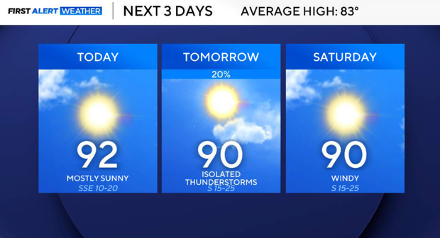
Saturday still looks largely dry. A strong cap and stable air should keep most, if not all, of North Texas rain-free despite isolated storm development staying well west of our area.
Ultimately, the day will be warm, humid, and breezy with highs in the upper 80s to low 90s.
Much of the daytime Sunday still looks dry. By late afternoon and evening, thunderstorm chances begin increasing, especially west and northwest of the DFW Metroplex as disturbances approach.
Early next week
Monday and Tuesday currently look like the best opportunities for more widespread showers and thunderstorms. Coverage may increase to 40% to 60% as disturbances move in from the west, and a weak front approaches from the north.
Not everyone will see rain, but this looks like our most active stretch in the forecast.