First 100-degree days of the summer approach as wind gusts increase for North Texas


Heat gradually builds through the weekend. While Thursday will still be fairly typical for late June, temperatures continue to climb each afternoon through early next week.
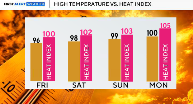
Some locations could reach their first 100° day of the year this weekend or early next week, with afternoon heat index values approaching 105° at times.
Breezy south winds continue. Gusts of 30 to 35 mph Friday through Monday will provide some mixing during the afternoon, but they'll also keep overnight temperatures warm and muggy with very little relief.
Rain chances fade away. After several active days, upper-level high pressure is taking over. Aside from an isolated shower or two on Friday morning, North Texas looks mainly dry through at least the middle of next week.
Thursday night will be partly cloudy, warm and breezy. Most of North Texas remains dry with only a very isolated shower or thunderstorm possible near the Red River. Temperatures fall through the 80s this evening with south winds continuing around 15-25 mph.
South winds continue overnight, preventing much cooling, especially in the metroplex and urban areas.
Breezy and even hotter weekend in North Texas
Friday will be mostly sunny, hotter and breezy. Afternoon highs reach the upper 90s with heat index values generally between 100° and 104°. South winds increase to 15-25 mph with occasional gusts over 30 mph. Only a very isolated shower or two is possible during the morning hours.
Saturday in North Texas will be mostly sunny, hot and windy. Highs climb into the upper 90s, with a few western locations nearing 100°. Heat index values may briefly approach 105° in some areas. South winds remain gusty between 15-25 mph with gusts to 30-35 mph.
And Sunday will be very hot and humid. Highs near 99° to 100° with heat index values close to 105° during the afternoon. Heat Advisories may become necessary for portions of North Texas depending on humidity levels. Breezy south winds continue.
Saharan dust arrives early next week
Forecast models indicate a plume of Saharan dust will move into North Texas late Sunday into Monday. The biggest impacts will likely be hazy skies, more colorful sunrises and sunsets, and a slight reduction in air quality for sensitive groups, including those with asthma or other respiratory conditions. The dust may also help suppress additional rain chances as the hot, dry air settles over the region.
Little change in the overall pattern. Mostly sunny, hot and windy with highs around 100°. Heat index values near 105° remain possible. Warm overnight lows near 80° continue due to persistent southerly winds.


