Heavy rain, isolated disruptive storms to move through North Texas Wednesday; flood watch in effect


A few showers are moving through western counties, while others are waking up to plenty of clouds on Wednesday, which is now a First Alert Weather Day. Be prepared for severe storms and flash flooding.
Scattered storms are popping up across North Texas, some of which may meet severe criteria. In fact, the Storm Prediction Center has highlighted a marginal risk for the metroplex and a slight risk for counties further west. This means that isolated to scattered severe storms will be possible.

Flooding is the primary threat; widespread totals of 1-4" will be likely through Friday morning, but some areas may receive around 7". This is why the National Weather Service has issued a flood watch that is in effect until 7 a.m. Friday morning. Remember, turn around, don't drown.
Winds around 60 mph or stronger are likely with any severe storm, and the tornado threat is low but non-zero.
A lull may occur in the evening before Wednesday night's big event. A complex of storms is expected to push through the area overnight into Thursday morning. Along the I-35, the metroplex will see intense rainfall and strong storms as early as 3 a.m. to as late as 10 am. Big impacts are expected for the Thursday morning commute.
Thursday remains a First Alert Weather Day due to the threat of flooding and areawide strong storms.
A flood watch went into effect beginning Wednesday afternoon and continues through Friday morning. At least 2" to 4" of rain is likely across most of North Texas, with a swath of 6"+ inches possible depending on where the front stalls out.
More storms are likely throughout the day on Thursday. Another strong round of storms is likely on Thursday afternoon.
Plan to leave your house a little earlier on Thursday, as heavy rain is likely to continue before and during the morning commute, causing ponding on roadways.
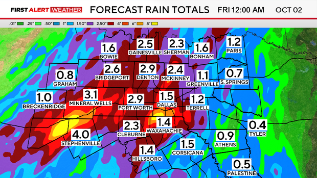
The weather pattern will stay active through the weekend. Showers and a few storms will be possible on Saturday, with rain chances dwindling on Sunday. Sunshine returns, and cooler temperatures are expected for the first week of October.
The rain will continue throughout the day, but there may be a break at times. There is a low-end level 1 risk of severe storms as this system moves through, with the potential to produce gusty winds.
Heavier rain gradually pushes east on Friday, although there is a chance some of these linger across DFW for the morning drive.
Looking ahead to the weekend, there will be lingering showers on Saturday with some clearing and drier conditions on the way for Sunday afternoon.
Expect plenty of sunshine early next week with morning temperatures in the lower to mid-60s.