Rain, cooler temperatures on the way to North Texas after one more 90-degree day


A flood watch is now in effect through late Thursday night for Eastland, Jack, Montague, Palo Pinto, Stephens and Young counties, where repeated rounds of showers and thunderstorms could produce 1–2 inches of rainfall, with isolated totals up to 4 inches. This could lead to flooding of creeks, streams and low-lying areas, especially where heavy rain persists. The greatest rainfall and flooding potential will remain west and northwest of the metroplex, with much lower rainfall amounts expected across DFW.
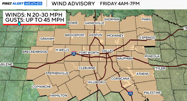
A wind advisory has been issued for all of North and Central Texas, including the entire DFW metroplex, from 4 a.m. to 7 p.m. Friday.
Behind Thursday night's strong cold front, sustained north winds of 20–30 mph with gusts up to 40–45 mph are expected throughout much of the day. These strong winds could make driving difficult, especially for high-profile vehicles, and may cause small tree limbs to break. Residents should secure Halloween decorations, patio furniture, trash cans and other loose outdoor items.
Summer Thursday… fall Friday
Ahead of the front, temperatures will climb into the 80s and lower 90s, with warm and humid conditions continuing across much of the metroplex. Showers and thunderstorms will become more widespread across western North Texas Thursday afternoon and evening. However, rainfall coverage will decrease toward the east and southeast, meaning many metroplex neighborhoods could receive little or no measurable rain.
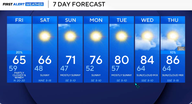
Behind the front, winds will quickly turn northerly, temperatures will fall, and much cooler, drier air will spread across the region. Friday will be windy and chilly compared with recent days, with highs around 65° in Dallas–Fort Worth. By Saturday morning, many of us will wake up to temperatures in the 40s.
Wide range of temperatures for North Texas on Thursday
Expect a wide range of temperatures across North Texas. Areas northwest of the metroplex will remain cooler where clouds and showers are more persistent, while Dallas–Fort Worth and locations farther south and east will climb into the upper 80s and lower 90s.
South winds will become breezy ahead of the approaching front. Scattered showers and thunderstorms will continue across northwestern North Texas, with additional development expected this afternoon as the front approaches.
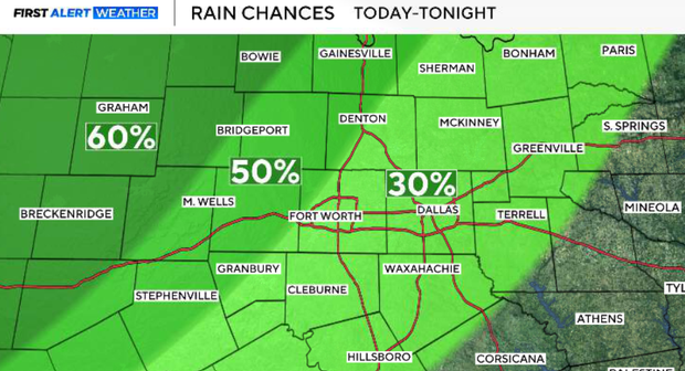
The highest rain chances, around 60–80%, will extend roughly from Cisco through Mineral Wells to Gainesville. Farther east, including the I-35 corridor and the metroplex, rain chances will generally range from 30–50%, with lower probabilities toward our southeastern counties. Mid-level dry air will limit thunderstorm coverage as activity approaches the metroplex.
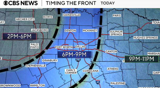
The cold front will begin moving into our northwestern counties late Thursday afternoon and early evening, reaching the DFW area around sunset, approximately 7 p.m. The timing may vary by location, but viewers should expect a noticeable wind shift from the south to the north as the front passes.
Thunderstorms will be most numerous west and northwest of DFW, especially during the late afternoon and early evening. A few stronger storms could produce gusty downburst winds, although the overall severe weather threat remains low.
As the front moves east and southeast, thunderstorm coverage should decrease.
A brief band of showers could develop along the front, but widespread heavy rainfall is unlikely across the metroplex. Some western and northwestern locations could receive substantial rainfall, while areas east of I-35 may receive only light rain or none at all.
A dramatic change begins behind the front.
North winds will increase to 15–25 mph, with gusts around 30–35 mph before midnight. After midnight, winds will strengthen further, with occasional gusts reaching 40–45 mph. Temperatures will fall rapidly into the 60s and eventually the 50s, with overnight lows ranging from the lower 50s northwest to the lower 60s southeast. Showers may linger behind the front into the late evening or overnight, but rainfall will gradually end as drier air moves into North Texas.
Strong north winds in DFW
Friday will feel completely different from Thursday.
Strong north winds will continue throughout much of the day, with sustained speeds of 20–30 mph and peak gusts of 40–45 mph. The strong winds will be driven by a tight pressure gradient as high pressure builds southward behind the cold front. Cold air advection will continue through the day, keeping afternoon temperatures much lower than earlier this week. Highs will be around 65° in Dallas–Fort Worth, with lower 60s northwest and somewhat warmer conditions farther southeast. Skies will gradually clear, and humidity will drop significantly.
It is a good idea to secure loose outdoor objects and use caution when driving high-profile vehicles, particularly on east-west roads where north winds will produce strong crosswinds. Winds will finally begin diminishing Friday evening and overnight.
Saturday morning will bring some of the coolest temperatures we've experienced so far this season. Morning lows will fall into the 40s across much of North Texas, including the upper 40s around DFW. With lighter winds, dry air and clearing skies, conditions will be favorable for strong overnight cooling. The afternoon will be beautiful, with sunshine, light winds, low humidity and highs mainly in the 60s. A perfect fall day for outdoor activities.
Sunday will bring another chilly start, with morning temperatures generally in the 40s and lower 50s. Sunshine will continue, with afternoon highs returning to the 70s. Winds will gradually turn easterly as surface high pressure shifts eastward.
Moderate temperatures next week
Temperatures will slowly moderate as the cool air mass begins retreating. Highs should remain closer to seasonal averages Monday, with many locations returning to the lower 80s by Tuesday. Moisture return will be relatively slow, so mainly dry conditions should continue.
Wednesday, southerly flow will become more established, allowing temperatures to climb into the middle and upper 80s. The cooler weekend weather will be a temporary break from our unusually warm October pattern.