Coldest air of the season to move in as temperatures stay in 40s to start weekend in North Texas

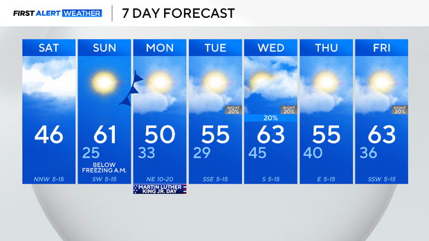
It is a cold start to the weekend, with temperatures dipping into the 30s across North Texas.
The winds on Saturday morning are from the north, around 5 to 15 mph, making it feel more like the low 30s and 20s. Cloud cover will be heavy through most of the day, and winds will remain breezy from the north, gusting up to 20 mph at times.
There is a possibility of a few sprinkles and snow flurries for those along the Red River Valley. However, if any precipitation does fall, the likelihood of it making it to the ground is very slim due to the dry air at the surface.
If you're going to the All-Western Parade in Fort Worth, bundle up! It will be cold and cloudy, with temperatures staying in the 40s for most of the day.
Dry and windy weather will increase fire danger on Saturday as well. Please avoid any activities that may cause a spark or a flame.

Overnight, cloud cover will gradually decline. Sunday, the coldest air of the season is expected in the morning. Temperatures will fall below freezing in the morning, so please remember to protect your pets, plants, pipes and people.
Sunday afternoon temperatures will quickly rebound in the low 60s. Sunshine will be abundant, and winds will be from the southwest, gusting up to 20 mph at times.
Another cold front is set to cool temperatures off once again on Martin Luther King Jr. Day. The low will once again be in the 30s, high in the 50s, and gusty winds from the northeast will make it feel even cooler.
It has been very dry over the last two months; the next potential for rainfall is on Wednesday. Chances are low as of now, so stay tuned for the latest forecast updates.