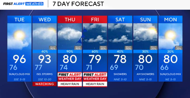
North Texas to see isolated storms with temperatures in the 90s to begin week; cold front may bring heavy rain


A significant pattern change is developing this week after our prolonged stretch of hot and predominantly dry weather.
The persistent ridge finally breaks down as a deep Pacific trough approaches from the west. At the same time, deep tropical moisture associated with Polo will be pulled northeastward into Texas and combine with increasing Gulf moisture.
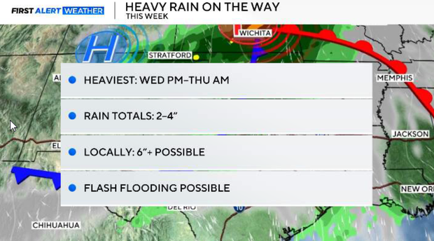
By Wednesday, precipitable water values climb to around 2.0–2.2"+, providing an unusually moisture-rich atmosphere. The approaching trough, upper-level jet and a Pacific front will provide the lift needed to produce multiple rounds of widespread rain and thunderstorms. Current guidance supports widespread storm totals of 2–4 inches, with isolated amounts above 6 inches possible. The exact placement of the heaviest rainfall remains uncertain.
It remains summer-like Monday with highs in the lower to middle 90s and plenty of humidity; 30% scattered showers and thunderstorms remain possible, although coverage should be limited.
The better chances Monday afternoon favor western portions of the region and areas farther east. The atmosphere will support a few stronger storms capable of gusty winds, small hail, frequent lightning and brief heavy rainfall, but widespread severe weather is not expected. Storm coverage should decrease quickly after sunset.
Quiet and mild conditions return Monday night with continued southerly winds. Overnight lows will generally fall into the lower to middle 70s.
Tuesday will essentially be our last mainly dry and hot day before the pattern changes. Highs climb into the lower to middle 90s as deeper moisture continues building ahead of the approaching system.
Widespread rain develops on Wednesday
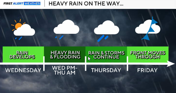
The pattern change gets underway Wednesday. Tropical moisture associated with Polo will be drawn northeastward into Texas, while Gulf moisture continues to increase from the south.
At the same time, the approaching trough and strengthening upper-level jet will provide significant lift. Rain and thunderstorms should become increasingly widespread during the day, with rain chances climbing to around 90%. The threat of heavier rainfall should increase on Wednesday afternoon and evening.
This currently appears to be the most likely period for the heaviest rainfall and greatest flooding concern. With an exceptionally moist atmosphere in place, thunderstorms will be capable of producing very heavy rainfall rates. Multiple rounds could also move across some of the same locations.
Current guidance supports:
- Widespread rainfall: 2 – 4 inches
- Isolated amounts: over 6 inches possible
The exact corridor of heaviest rainfall remains uncertain, but confidence continues to increase in a widespread heavy-rain event.
Rain with flooding possible Thursday
Rain chances remain very high, around 90%, with additional periods of heavy rain and thunderstorms possible on Thursday. By this point, areas receiving repeated rounds of rain will become increasingly susceptible to localized flash flooding. Clouds and rain will also have a noticeable impact on temperatures, with highs falling into the 70s and 80s across portions of North Texas.
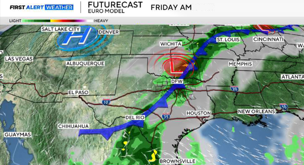
The Pacific front will push through North and Central Texas on Friday, but the rain may not immediately end behind it. The upper-level low could become cut off from the main flow, allowing additional showers and thunderstorms to continue. Rain chances currently remain around 60% Friday.
Rain chances linger into next weekend
Rain chances may linger into Saturday and Sunday, although coverage should gradually decrease. Depending on how long the upper low remains nearby, additional rainfall will be possible.
Temperatures will finally be much closer to seasonal averages, with highs generally in the upper 70s and lower 80s and some morning lows potentially falling into the upper 50s and 60s. After weeks of persistent heat, next weekend should finally look and feel much more like fall.