Clouds, temperatures in the upper 80s expected as isolated rain, storm chances continue for North Texas


Daily storm chances continue through the weekend, with the best opportunity for more widespread rain and thunderstorms expected on Saturday. While severe weather is not expected to be widespread, a few stronger storms could produce gusty winds, frequent lightning, and locally heavy rainfall.
Tuesday's storms brought highly variable rainfall totals across North Texas. Some locations picked up 2 to 4 inches of rain, while others barely saw a drop. DFW officially received 2.31 inches of rainfall, helping chip away at our yearly rainfall deficit.
Lower storm coverage (20%) is expected Wednesday evening behind Tuesday's front. Expect a mix of clouds and sunshine with highs near 90 degrees. Any storm that develops could produce gusty winds, frequent lightning, and brief heavy rainfall.
Any isolated storms will diminish after sunset, leaving partly cloudy skies and mild overnight temperatures in the upper 60s to lower 70s.
End of the week storm chances
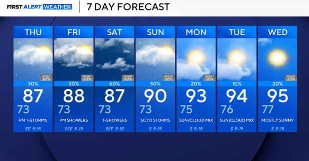
Storm chances increase slightly on Thursday as moisture remains in place and another disturbance approaches from the west. Scattered afternoon and evening showers and thunderstorms are expected, although many locations will still remain dry for much of the day. Highs will stay in the upper 80s.
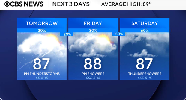
Scattered showers and thunderstorms on Friday remain possible during the afternoon and evening hours. Coverage should be similar to Thursday, with periods of dry weather mixed in between storm chances. Any stronger storm could produce gusty winds, lightning, and locally heavy rainfall.
Saturday appears to be the wettest day of the forecast. A stronger disturbance moving across North Texas is expected to bring a good chance of showers and thunderstorms across the region. While widespread severe weather is not expected, a few storms could produce gusty winds, small hail, frequent lightning and locally heavy rainfall.

Sunday and early next week, rain chances begin to decrease, although isolated to scattered showers and thunderstorms will remain possible. Temperatures stay seasonably warm with highs generally in the upper 80s to near 90 degrees.
On a side note: Tropical Storm Amanda developed over the open waters of the Pacific Ocean on Wednesday, becoming the first named system of the eastern Pacific hurricane season.