Heat advisory in effect as North Texas as elevated fire threat continues


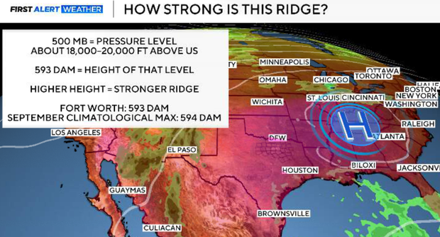
An unusually strong upper-level ridge remains the dominant feature across the Southern Plains and is responsible for our persistent September heat. In fact, Monday evening's Fort Worth sounding measured the 500-mb height at 593 dam, very close to the highest value in the SPC sounding climatology for this time of year, 594 dam. That's an indication of just how anomalously strong this ridge is for mid-September. The ridge keeps us hot, mostly sunny and rain-free through the remainder of the workweek and into Saturday.
A heat advisory is in effect through 8 p.m. Wednesday for portions of North Texas, mainly east of I-35. Highs will reach the upper 90s to lower 100s, and higher humidity east of I-35 could push heat index values above 105°.
Elevated fire threat continues in North Texas
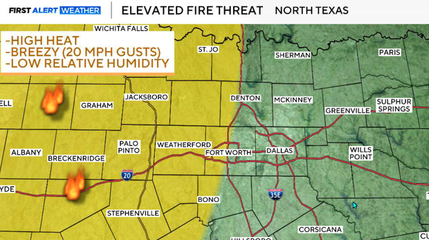
An elevated fire threat continues, particularly west of I-35, where afternoon humidity drops to around 30% and south winds may reach around 20 mph. However, there is finally a change showing up.
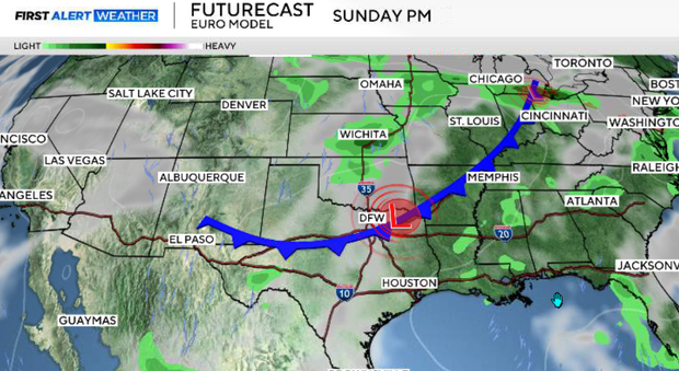
The ridge begins weakening this weekend as a trough strengthens across the western U.S. This should allow a cold front to move into northern North Texas Sunday night, bringing increasing thunderstorm chances late Sunday through Monday and at least some relief from the heat.
Tuesday night
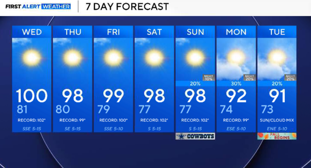
Another extremely hot September afternoon will carry into the evening. DFW is forecast to reach around 100–101°. Tuesday's record high is 100° from 1980, meaning we could at least tie and potentially break the record. Higher humidity east of I-35 will make it feel even hotter, with heat index values exceeding 105° in some locations.
We will have clear skies and another very warm night. Temperatures will generally fall into the mid and upper 70s, with readings around 80° in DFW. South to southeast winds continue overnight.
Fire Danger
The combination of very hot temperatures, dry vegetation, lower afternoon humidity and breezy south winds will create another elevated fire-weather environment. The greatest concern is west of I-35, where relative humidity could fall to around 30% and winds may reach around 20 mph. Any grass fire that starts could spread quickly. This concern is particularly important with ongoing fires already burning across parts of the region, and the elevated grass-fire threat is expected to continue through the week.
Wednesday, we will see very little changes. The strong ridge remains in control, keeping North Texas sunny, hot and dry. Highs will once again reach the upper 90s to around 100°, with heat index values near 105° in the more humid locations. The elevated grass-fire threat also continues.
Dry spell continues through the end of the week
The ridge remains exceptionally strong through the end of the workweek. A little sea-breeze activity may develop farther south Thursday, but most of that precipitation should remain in Southeast Texas. North Texas stays predominantly dry. Highs remain near 100°, with heat index values around 105° possible. By Friday, the ridge should begin showing the first signs of weakening as the larger-scale pattern starts changing to our west.
Saturday still looks hot and predominantly dry, with temperatures in the upper 90s to near 100°. However, changes occurring aloft will begin setting the stage for a more noticeable shift later in the weekend.
Sunday and Monday finally bring a change in weather to North Texas
This is the period we're watching closely.
As the ridge weakens and a trough amplifies across the western U.S., a cold front will begin sliding south. This front could provide some of the better widespread rain chances we've seen in quite a while. The front should reach the Red River counties after dark Sunday.
Ahead of it, shower and thunderstorm chances begin increasing late Sunday, with additional storms possible Sunday night and Monday as the boundary moves farther into North Texas. There is still uncertainty regarding exact timing and coverage, so it's too early to lock in specific rain probabilities... but we are looking at 30%-50% chance of rain as of right now.
This does not currently look like enough rain to erase our drought, but after our exceptionally long dry stretch, any meaningful rainfall would be welcome. The front should also bring slightly cooler temperatures, potentially getting us closer to normal by Monday.
Looking ahead
The important change isn't simply the front itself. The upper-level pattern finally becomes more progressive as the dominant ridge weakens. That should at least temporarily break the stagnant hot-and-dry pattern that has dominated much of September. Confidence is increasing in a Sunday night/Monday change, but we'll continue refining the front's exact timing, rain coverage and temperature drop over the next several days.