Cold Night On The Way
FORT WORTH (CBSDFW.COM) - Another cold front is about ready to pass through Corsicana, Athens and Quitman. Ahead of the front temperatures are very warm.
In Corsicana at 3pm the temperature was 79 degrees, 74 in Hillsboro, and 82 in Waco. But at DFW behind the front it is 59 degrees with a Northwest wind blowing at 25 miles per hour. Winds will decrease later this evening but with clear skies, dry air, and cold air still moving into North Texas it will be cold.
We will see lows in the mid to upper 30s around the area. Most locations will stay above freezing, but a few of the low lying valleys well to the north and west of DFW may reach freezing early tomorrow morning. Grab that heavier jacket for tomorrow morning and get the kids bundled up. Tonight will be the coldest night since February 13.
Sunny skies for Tuesday and light winds will help temperatures warm into the mid 60s and upper 60s Tuesday afternoon. So chilly in the morning than a nice afternoon.
MOISTURE RETURNS SETS UP NEXT STORM CHANCE
Wednesday will see winds return to the south and increase moisture from the Gulf of Mexico into North Texas. We will see clouds quickly return Tuesday night and all of Wednesday will be mostly cloudy. We could see a few spotty areas of drizzle and light rain on Wednesday. But the moisture increase will be in response to an area of low pressure forming in eastern Colorado that will move across Oklahoma on Thursday.
THURSDAY'S STORM CHANCE
The above mentioned low will be moving into Oklahoma Wednesday night as a upper level disturbance moves over Texas and Oklahoma. This low will be moving relatively fast and push a pseudo dryline/cold front into North Texas Wednesday night into Thursday morning. During the morning will be our opportunity for rain and storms.
The way the timing of this is setting up is not always conducive for us to see storms, but if the upper level energy is still strong enough (it will be weakening as it moves east) we could see a few storm Thursday morning. One of our models the NAM doesn't fire up storm until the dryline is east of Dallas. The European and GFS are much more aggressive in developing storms Wednesday night and sweeping them across the area Thursday morning. With that being said, we will certainly have our best shot at rain in several days and for those areas east of Dallas there is a much higher probability of seeing rain and storms. Any of these storms will have the capability of being severe on Thursday morning.
Behind the dryline it will turn windy and warm. West winds will kick in behind the dryline and likely gusts to 35 or 40 mph. Temperatures will warm into the upper 70s. Fire Weather Watches and Red Flag Warnings will likely be issued Thursday afternoon for areas west of Fort Worth.
COOLER AIR ARRIVES THURSDAY NIGHT
Finally as the storm system on Thursday morning departs east the cooler air will move in Thursday evening. Lows Thursday night will drop into the low 40s and highs on Friday will be in the mid 60s.
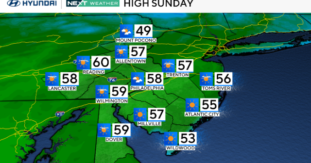
WEEKEND OUTLOOK
It will be breezy and mild on Saturday with highs in the low 70s, but a cold front will back its way into the area on Sunday dropping highs into the 50s and keeping it breezy. We could see a little rain on Sunday at 20% coverage.