Storms threaten North Texas with heavy rain, gusty winds and hail before a Labor Day weekend cooldown
A cold front moved in Thursday afternoon/evening, bringing strong thunderstorms for parts of North Texas, leading to gusty winds, heavy rain at times, and even a landspout in Little Elm.
That front also led to a steep drop in temperatures, and will give us much cooler than normal temperatures going into the holiday weekend.
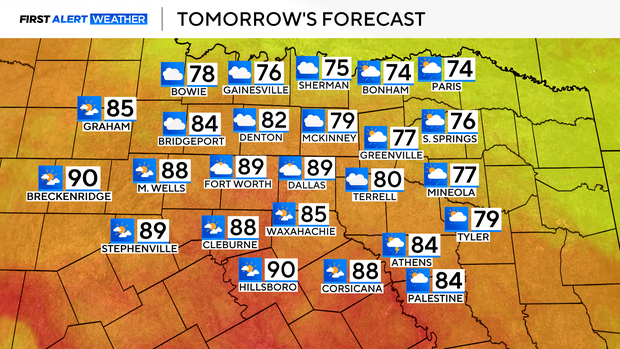
For our Friday, expect isolated shower chances as the front remains stalled to our south. This will result in quite the temperature gradient on Friday afternoon, with highs in the upper 80s for the metroplex, but highs in the mid to upper 70s along the Red River.
As we get into the rest of the holiday weekend, our ridge of high pressure moves west, allowing a series of disturbances to roll into North Texas.
Our greatest shower coverage looks to be on Saturday, with a few lingering, spotty showers into Sunday as well.
By Labor Day, most of the area dries out, and we'll start to warm back up. The weekend is not a washout, but a good idea to keep the umbrellas handy. And remember, when thunder roars, head indoors.