North Texas Temperatures Falling Through Morning, Afternoon Before Rain From Arctic Front Begins
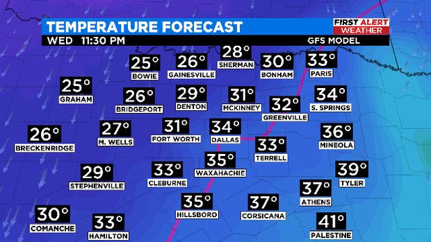
NORTH TEXAS (CBSDFW.COM) — The arctic front is moving into North Texas this morning. Temperatures have already begun to fall in areas to the northwest and this trend will continue throughout the day.
The Metroplex is under a Winter Storm Warning from 6:00 p.m. today until 6:00 p.m. Thursday, ice accumulation of .25"-.5" is possible with snow and sleet accumulations of 1"-3" possible.
Precipitation will begin as rain and transition to freezing rain in DFW around the evening commute and in northwest areas around lunchtime. Overnight, freezing rain and sleet will transition to all snow by Thursday morning. The snowfall will continue into Thursday afternoon.
Travel will become hazardous from Wednesday afternoon until Friday morning. Drivers are being urged to stay off the roads if at all possible.
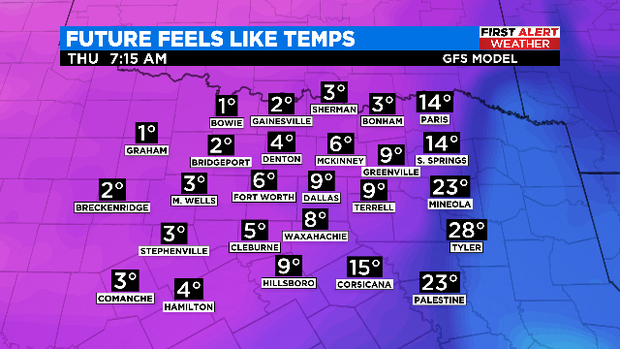
All of Thursday will feel like the single digits due to strong northerly winds, the cold air in place and icy precipitation. North Texas will wake up to wind chills to -5° in some of the western counties on Friday morning.
Expect slight melting to occur on Friday as some spots warm above freezing and the sun returns. The real thaw doesn't arrive until the afternoon hours this weekend. Anything that does melt during the day will refreeze overnight, as temperatures fall into the teens and 20s on Saturday and Sunday morning.