Major weather threats bring blizzard conditions to U.S. northern tier, early heat wave to the West
Severe weather threats across the United States have millions of Americans on alert for blizzard conditions, potential tornadoes and record-breaking high temperatures in the coming days. Successive punches of snow and wind are set to impact the eastern half of the country on Monday, after weekend storms made roads impassable in the Upper Midwest.
The storm system that brought blizzards and life-threatening travel conditions to the Northern Plains and Upper Great Lakes on Sunday is moving east, threatening the region with potentially damaging winds and tornadoes. Forecasters said mid-Atlantic states and Washington, D.C., were at greatest risk for both of those.
The cold front was expected to move off the East Coast by Tuesday, bringing sharply colder weather in its wake, forecasters said.
The late winter blast comes as Hawaii continues to be affected by a separate storm system that caused severe flooding over the weekend, and as parts of the West experienced an unusually early heat wave that was expected to last through much of the week.
Blizzard slams Northern Plains, Upper Great Lakes
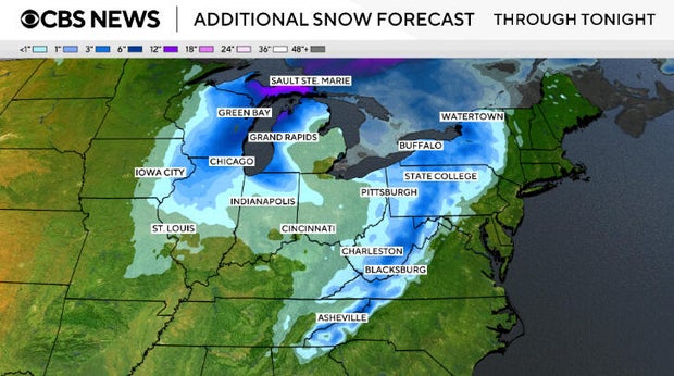
Intense blizzard conditions persisted Monday in parts of the Upper Midwest, after the storm brought as much as 2 feet of snow to parts of Michigan and Wisconsin by morning.
Additional snowfall of a foot to 20 inches of snow can be expected in upper Michigan, along with gusty winds, on Monday, the National Weather Service said. Schools were closed in a number of communities in both states on Monday, including Milwaukee and Marquette, Michigan.
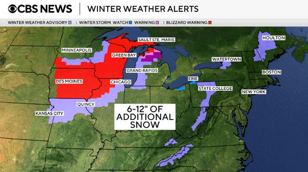
Blizzard warnings were still in effect Monday evening and expected to last until at least Tuesday morning, as heavy snow tapered off but lingered on the backend of the storm system, CBS News meteorologist Nikki Nolan said, noting the Great Lakes region was expected to see between 6 and 12 inches of additional snowfall.
So far, the highest snowfall reports from the blizzard came from sections of Michigan and Wisconsin, where 33 to 36 inches have piled up as of Monday night, according to Nolan.
More than 600 flights flying out of and into the Minneapolis-Saint Paul International Airport were canceled on Sunday, according to FlightAware, a website that tracks flight disruptions. At O'Hare and Midway international airports in Chicago, more than 550 flights were canceled Monday.
A no-travel advisory that had been issued in southern Minnesota was lifted Monday. Gov. Tim Walz had authorized the Minnesota National Guard to support emergency operations ahead of the storm, CBS Minnesota reported.
Wisconsin snowplow driver Aaron Haas said it was one of the worst storms he had seen in years. On Sunday, he was stacking piles of snow as high as his truck in the town of Marshfield.
"You can't see anything when you're on the highways outside of the city," he said.
Blizzard conditions are likely to stretch into Monday with additional lake-effect snow behind the storm.
Severe weather threat expanding east
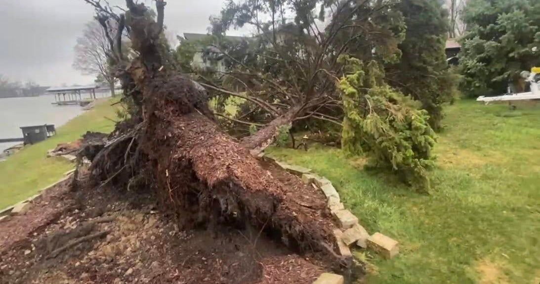
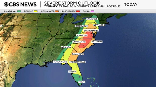
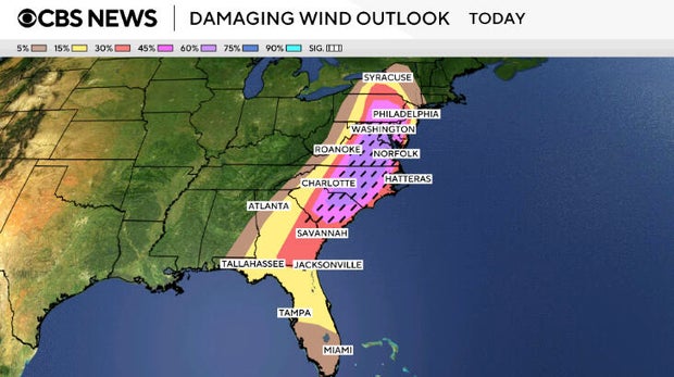
The storm system that dropped snow by the foot in the Midwest barreled toward the East Coast with dangerously high winds and potential for "producing strong and long track tornadoes," the National Weather Service warned Monday.
"Wind is the primary threat, but within any of these areas of strong wind there could be some embedded tornadoes and even the potential for a tornado to develop ahead of the line," said Evan Bentley, a meteorologist with the weather service.
The biggest threat stretched from Maryland to the upper edge of South Carolina.
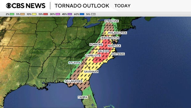
A stretch from parts of South Carolina to Maryland appeared most likely to experience particularly damaging winds Monday afternoon, the weather service said. That could include Raleigh, North Carolina; Richmond, Virginia and the nation's capital. The weather service said an increased — albeit much lower — risk stretched north to a portion of New York and south to northern Florida.
Officials said schools in Raleigh and Chapel Hill, North Carolina, would be closed on Monday. Gov. Josh Stein urged residents to enable emergency alerts on their phones ahead of expected wind gusts topping 70 mph.
A 97 mph wind gust was reported Monday in Whiteface, New York, which was well to the north of the forecasted severe threat area.
Freeze Alerts were being issued Monday in the Southeast behind the cold front, with below freezing temperatures as low as the teens expected through Wednesday morning in the region as winds cool things down more than usual for this time of year.
Wind chills below freezing were expected to reach the Gulf Coast and the Florida Panhandle by Tuesday with warnings also in effect in parts of Arkansas, Oklahoma, Louisiana and Texas, forecasters said. To the North, rain was expected to change over to snow behind the cold front with heavy snow possible in the central Appalachians of West Virginia.
Early-season heat builds in the West
While the central and eastern U.S. brace for storms, the western U.S. is heading into an unusually early heat wave driven by a strengthening ridge of high pressure.
Beginning Monday and continuing through much of the week, record-high temperatures are possible across Southern California, the Desert Southwest and the Great Basin, forecasters said. Desert areas could see temperatures climbing into the 90s and 100s, while much of California and the interior West may experience highs in the 70s and 80s.
The warm, dry, and windy pattern is also expected to increase wildfire danger across parts of the West and High Plains.
In Nebraska, about 30 National Guard members were deployed over the weekend to help combat multiple wildfires across a broad swath of range and grassland, the state's Emergency Management Agency said.
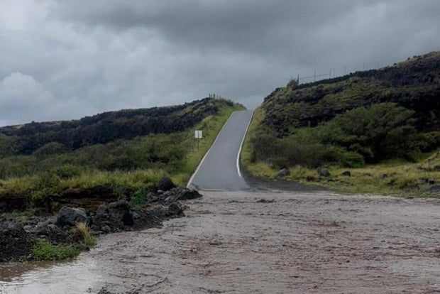
Landslides, rescues, and collapsed homes on Maui
Acres of farmland and homes have been flooded in Hawaii. Roads have been closed, and shelters opened. PowerOutage.us, which tracks outages nationwide, reported over 30,000 electric customers in Hawaii without power as of Sunday evening.
Flash flooding has been a major problem in recent days in places like Maui, Molokai and the Big Island, where rain had been falling from 1 to 2 inches an hour overnight, according to the Hawaii Emergency Management Agency.
Maui County Mayor Richard Bissen said in a social media post late Saturday that some areas of Maui had received 20 inches of rain in the previous 24 hours.
"We're seeing flooding, landslides, sinkholes, debris and downed power lines across the county," he said. Expressing gratitude in the Hawaiian language, the mayor added "mahalo for continuing to look out for one another."
Video footage in Bissen's post showed washed-out or collapsed roads, a car stuck by floodwaters and raging waterways. National Guard members and fire department workers made multiple floodwater rescues, Bissen said.
All of Hawaii's islands had spots with more than 15 inches of rain, while parts of Maui were overwhelmed with double that amount, the weather service said.
While the worst of the storm had passed as of Monday, more heavy rain is expected later this week. Bissen said there were no reports of injuries or deaths and crews were assessing damage.