Wildfire smoke rolls into Pittsburgh area today as scattered storm chances loom

Some wildfire smoke is rolling into the Pittsburgh area on Sunday, as scattered storm chances return to the forecast.
The thick plume of smoke has settled into the area, though the impact on air quality at the surface will be lessened because the haze is about 7,000 feet up.
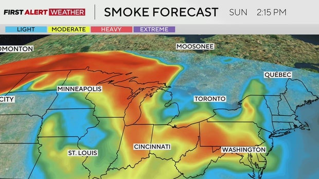
It won't be like what plagued the Pittsburgh area two Fridays ago, when Pennsylvania was under a Code Purple air quality alert due to very unhealthy air quality.
Pittsburgh's Sunday forecast
Highs on Sunday will hit in the low 80s, while noon temperatures should be in the mid-70s.
Things should be dry before 2 p.m., and while storms will be around after 2 p.m., there will still be gaps in the rain.
Uncertainty for Monday
Are there any Alert Days Ahead? Well, there is a lot of uncertainty for Monday due to severe storms. It's just as likely to be entirely dry as it is to see storms, but any storms will be intense.
When KDKA's First Alert Meteorologists make a severe weather forecast, they are generally looking for three things: instability, moisture, and some form of a trigger to set off storms, like a cold front or outflow boundary.
The presence of all three of those things is no guarantee of severe storms, and they try to note things that may impede storm development, like a robust stable layer or "cap" being in place. Severe weather is never guaranteed due to the complex number of things that have to go right, or in this case wrong, for the storms to occur.
Some severe weather days occur exactly like we thought they would, but that is certainly not the norm. Oftentimes, severe storms develop a little bit off of where we thought the "highest chance" would be. Sometimes they don't form at all.
At the end of the day, KDKA First Alert Meteorologist Ron Smiley always goes back to looking for the conditions of severe storms being met. That is all to say that it appears all ingredients for severe storm development will be in place Monday afternoon through Tuesday morning. Several things may impede storm development, but severe storm chances are certainly there.
Severe weather chances
Currently, the National Weather Service's Storm Prediction Center has the area under a level 2 of 5 severe storm risk on Monday into Tuesday morning.
Breaking down the three types of severe weather, they put us at having a high chance to see strong winds, with the chance for tornadoes and large hail being less than 2%.
KDKA First Alert Meteorologist Ron Smiley agrees that this is certainly a strong wind-type event, with straight-line wind speeds of up to 80 mph certainly being possible as storms race through from the northwest to the southeast. These storms will be tapping into the energy of the jet stream that will also be situated northwest to southeast over us. These types of storms also don't need as much energy to develop as they tap into the energy of the jet stream.
Timing out severe weather, the strongest storms should be around in the evening hours of Monday night to Tuesday morning. Fast-moving storms will not be widespread, but where they go will pack a punch. Damaging winds could knock out power to thousands of homes, topple some large trees, and leave debris on streets Tuesday morning.
Any storms before 6 p.m. should be fairly isolated on Monday, and there will be some that don't see any rain at all. Storm chances should come to an end around 10 a.m. on Tuesday with the passage of a cool front.