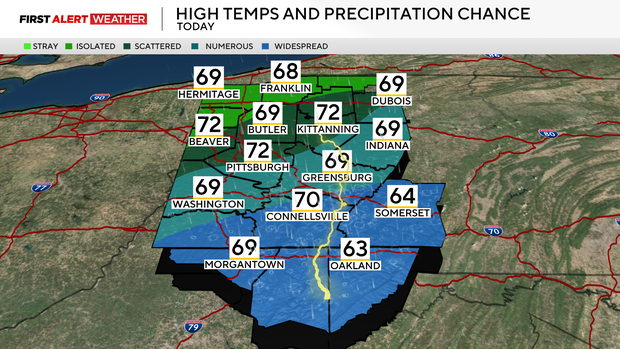
Widespread rain and thunderstorms to hit Pittsburgh area later Thursday

After a squall line brought severe storms, heavy rain and tornado warnings to the Pittsburgh area on Thursday morning, the atmosphere has temporarily stabilized across most of western Pennsylvania into northern West Virginia.
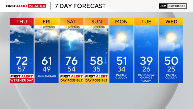
But widespread rain and thunderstorms are moving in again, and the weekend comes with a severe weather threat as well. Thursday is a First Alert Weather Day through the evening, and both Saturday and Sunday are possible First Alert Weather Days.
More rain and thunderstorms move in Thursday evening
A cold front will continue to move in from western Ohio toward western Pennsylvania through the afternoon and evening hours and eventually stall out just to the south of I-68 in Northern West Virginia Thursday night into Friday morning. A few isolated to widely scattered showers may occur with the front, but more widespread rain and thunderstorms will move in around 7 to 8 p.m. as a trough of low pressure aloft rides along and just north of the stationary front.
The overall severe threat Thursday evening and night is fairly low and limited to the Pittsburgh area's southern counties — mainly south of I-70. Hail would be possible with any of these cells, but there is no tornado threat and the strong wind potential should remain low as well.

Friday brings more rain and thunderstorms
Friday morning will start with some widespread rain, especially over from Pittsburgh and points south, but high pressure and sinking will nudge in from the north, leading to several hours with isolated rain showers as opposed to widespread activity.
Another surge of moisture and a weak disturbance moving in from the southwest will help to increase the rain and thunderstorm coverage Friday evening and especially overnight. There is some uncertainty as to when the next round of rain will start with some models showing as early as 5 to 6 p.m., while others lean toward after 9 p.m. Those headed to the Pirates' home opener should be prepared for rain in case.

Thunderstorms are likely Friday night into Saturday morning as moist and warm air continues to surge into the region with a warm front. The air nearest the ground will likely be cool and stable, so if anything were to turn severe, hail (up to 1 inch in diameter) would be the main threat.
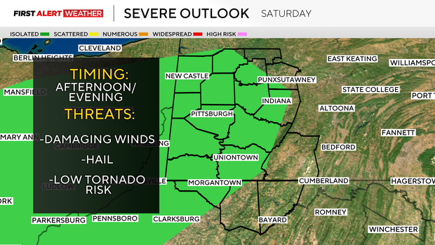
Saturday comes with severe weather threat
By Saturday midday into early afternoon, moisture values will continue to increase along with low level warmth, which will make the atmosphere unstable by this point. Numerous to widespread showers and storms are expected at various points during the day into the evening. There is a threat for severe weather—currently 1 out of 5 in place from the Storm Prediction, but it's possible this gets upgraded at a later point. Wind, hail and a tornado cannot be ruled out on Saturday.
Widespread heavy rain and thunderstorms will continue Saturday night into Sunday morning as a slow-moving cold front moves into the region. The rain should come to an end completely between 6 p.m. Sunday and midnight Monday, followed by a drier and cooler Monday afternoon.
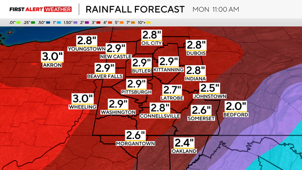
Area to see several inches of rain the next few days
Total rainfall amounts through the next five days continue to look impressive, especially from Pittsburgh and points north and west. Most models average out around an additional 2 to 3 inches of rain through Monday morning, however, the trend has been going up with isolated storm total amounts of 4 inches or more possible. The greatest threat for river flooding will be to our southwest along the middle and lower Ohio River and its tributaries, but some flooding could occur locally as well.
A colder air mass will build in toward the early to middle part of next week with rain and snow possible by next Tuesday.