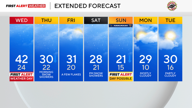
The roads in Pittsburgh will be wet, not snow-covered, as the weather remains rainy
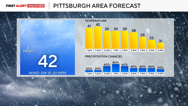
Most of the day on Wednesday, you'll just be dealing with wet roads. Temperatures will be in the mid to upper 30s. A front does come through around sunset, with temperatures dipping to the low 30s for the rest of the day.
WEATHER LINKS:
Current Conditions | School Closings & Delays | Submit Your Weather Photos
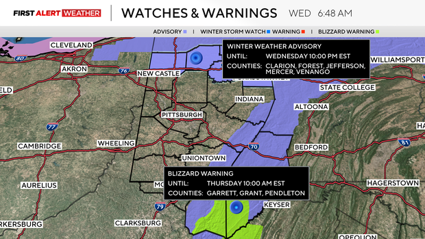
This is the time when snow on the roads will be possible. Let's put the time from 7 p.m. through 11 p.m., we could see a quick 1" of snow coming down on area roads tonight.
The reason the impact on snow will be low today is due to the temperatures. Temperatures above the surface are cold enough to support snow growth and to have the snow make its way to the surface. Surface temperatures and ground temperatures are just too warm for any snow that makes it to the surface to stick around for more than a couple of seconds.
I've been here long enough to know that on days like today, model data almost always underplays the quick movement of warm temperatures to the north in a set-up like what we are seeing. When a degree or two is the difference in accumulating snow and rain, small changes can make big real-world differences.
Looking ahead, we have one other potential First Alert Weather Day over the weekend.
On Monday, it looked like the First Alert Weather Day would fall on Saturday. Yesterday, it looked like it would fall on Sunday. Now you could make the case for both days having a First Alert Weather Day.
I will only keep Sunday as a First Alert Weather Day at this time.
This is because a couple of fast-moving systems will move through. The first actually arrives late on Friday, lasting into Saturday morning. Another mid-level low will slide through on Saturday evening through Sunday morning. Both of these waves will bring the chance for snow-covered roads.
Snow ratios will be higher for the Sunday morning snow chance. Right now, it looks like the Friday-Saturday snow chance will bring more snow, but due to higher ratios, I wouldn't be surprised if we still see more snow on Sunday.
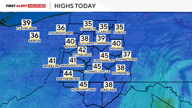
Getting back to today, highs have already hit the low 40s, and temperatures are more than 30 degrees warmer right now than they were yesterday at this time. Temperatures should hover near 40 through the afternoon, only going down behind the afternoon cold front around 5 p.m.
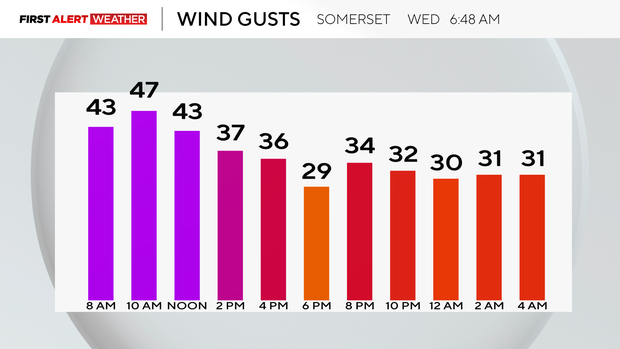
From 7 p.m. through around 11 p.m., snow-covered roads will be possible. The Pittsburgh area could see a quick inch of snow falling this evening. Don't forget about winds as well, with winds gusting up to 35 m.p.h. In Pittsburgh, and as strong as 50 m.p.h. in the Laurel Highlands. It appears the strongest winds will happen before 5 p.m.
Stay up to date with the KDKA Mobile App – which you can download here!